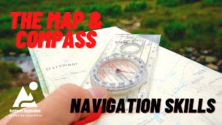
How to use a Map and Compass - Part 1 : Taking a Bearing from the map

ฝัง
- เผยแพร่เมื่อ 28 พ.ค. 2024
- This video is the first of a three part series and introduces you to the compass and its features.Using a practical example we then look at how to take a bearing from the map, allow for magnetic variation if required, and how to walk on that bearing in the field.
Link to Part 2 covering pacing and timing techniques below
• How to use a Map & Com...
Link to Part 3 covering what to do when you get lost
• How to use your map an...


Thankyou !! I’ve searched and searched for a video that explains this clearly . It’s all clicked now !!
Glad you found it useful Adam 🙂
I’ve been thinking of going hiking again for a little while( 40 years since last time) Need to refresh my skills and these 3 episodes have been by far the best on TH-cam Well done,
Thanks 😊
Thank you Gary, I am glad you found the videos useful. Good luck in your future hiking, and thanks very much for watching and taking the time to comment 😊
What an excellent video, very well explained and informative. I do lots of walking with my 3 children on known routes but am keen to use a compass and map to navigate, watching this has given us the bug to try out this weekend on familiar trails until we are confident to give it a go on somewhere unknown. Keep up the good work!
Thank you very much for watching and your kind comment Richard, I am glad you enjoyed the video. I hope you enjoy giving it a go this weekend 🙂
@@thecampingastronomer8554
Here in the USA it’s called ‘dog in the doghouse’ or ‘red in the shed’ and you sir are an excellent instructor!
Thank you for watching and your kind comment. I have not heard of putting the dog in the doghouse before - that's a great saying 🙂
A very good skill to have...used to teach my students in geography class this each year...it seems to be a lost skill with the use of cell phone technology...but the compass will never run out of batteries...great lesson...thanks so much!
Thanks for taking the time.to watch and comment, I am glad you enjoyed the video 🙂
Thanks, lovely clear explanation. Could have used thrse skills this weekend! Took a wrong turn on a foot path.
Luckily had phone / Google maps
Glad you found the video useful Graham. Every time we get lost, we add a little bit to our experience. When I get lost it is usually at the end of a walk when I stop paying attention. Once, I tried to convince myself that the map was wrong 🤣
Thank you John - loved your explanations and examples and I think I finally understand how to use a compass and map thanks to you! I can finally preserve my phone battery for other things and without worrying about runninv low! 😅
Thank you for your kind comment, Johir. I always find it very satisfying to use a map and compass to navigate, and as you say, it preserves your phone battery for other useful stuff. I hope you have a good week ahead 🙂
I'd always count 73 steps (starting with left, ending with right) for every hundred meters if there wasn't any references visible. Excellent video, sir 👍🏻🙏🏻
Thank you Tony. My main problem is remembering how many steps I take per 100m. I am thinking about putting it on a small label on my compass. Hope you enjoy the festive period 😊🎄
2200/mile or 23 minutes.
Excellent instructions. Thank you so much for explaining how to take a bearing in so much detail. I was really confused by all the other videos I watched.
Thanks for you very kind comment, I am glad you found this useful.
Have a good evening 🙂
You put out some really great topics and information. I try to look at the topo maps but you gave some great tips on things to look at that I hadn't considered. Thank you for taking the time and for doing a great job of explaining things.
Thank you for your kind words Theresa, I am glad you found the video useful 😊
Nice effect(s) of clouds rolling in for reenactment.
Thank you, hope you found the video useful 😀
Thank you Sir, this video is very informative plus excellent knowledge on navigation!
Thank you very much for taking the time to watch and make a nice comment. I very much appreciate this and am glad you enjoyed the video.
Thanks for sharing. I had forgotten how to work out magnetic variation.
Thanks Mark. Magnetic variation is a confusing subject I think. Luckily in the UK we can largely ignore it at the moment, so I'll be making the most of that good fortune for a couple of years.
I was last shown how to calculate it about 40 years ago. LOL. I always remember having a add a number of degrees to the bearing taken on a map. Thanks again.
Simple yet clearly explained 👍 I stand info beniftted,thank you
Thank you, glad you found it useful 👍
Thank you so much for taking the time to explain this. I've found it easy to understand and very informative. You used Gowbarrow Fell as an example which is actually a walk we did only last year!
Hello Cath, I am very pleased that you found the video useful. Gowbarrow is a fell I would like to go back to, as I expect you had much better views than me on the day I was there.
Thank you very much for taking the time to watch and make a comment, I really appreciate your support 😊
@@thecampingastronomer8554Lol, not at all the weather was awful and we got soaked! Our friend even had a puddle in her jacket pocket 🤣
@@cathgreenwood831 🤣🤣🤣
Well explained thank you.
Thank you Peter, glad you enjoyed it. Hope you enjoy the rest of the weekend 👍
Hi John. I hope you’re well. Trying to get through loads of camping videos that I’ve been meaning to watch for literally years😆
Got to this one. Some really useful stuff here mate. Things that anyone tackling wild camping in places like Dartmoor should have at least a basic understanding of. ATB. Al.
Hi Al, glad you found this useful. I always find moorland tricky to navigate across because it's relatively empty of features to help you locate yourself. Thanks very much for watching, hope you have a good week 😀
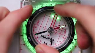
Excellent demonstration. I have used the same kind of compass, a bit more expensive (a Suunto) in total white-out zero visibility and with good effect.
Suggestions: (1) orient the paper map to magnetic north. Then you can read directions directly off the compass. Orienting the capsule markings to map north, as you did, accomplishes the same thing but slightly less accurate because of the short baseline inside the rotating capsule. (2) Beware anything magnetic near your body when you are sighting. It will deflect the needle and you'll end up going in the wrong direction or even in a circle.
(3) Watch out for the bubble; it will push the needle.
Thank you Thomas, and thank you for the tips. I often wonder if my phone will effect the compass. I usually keep my compass round my neck on a lanyard so I don't loose it. I worry a bit about keeping my phone in my jacket inside pocket in case it causes problems for the compass. Consequently my phone usually lives on my trouser pocket to keep it away from the compass.
Thank you very much for watching and for taking the time to comment, I really appreciate your support 😊
@@thecampingastronomer8554 It is unlikely the phone would affect the compass simply because many phones have a Hall effect sensor already in them that would be affected by their own magnetism, if any.
@@thecampingastronomer8554 On one hike in Alaska, one of my companions insisted on turning left no matter which way we were going. The problem turned out to be he was using a "lensatic" compass that you hold up to your eye, and he wore eyeglasses that oriented the needle such that north was always to his left.
@thomasmaughan4798 now that's a great story to have 😊
@thomasmaughan4798 thanks for that information Thomas, it's very useful.
Really enjoyed watching this. I’ve got a couple of these compasses which the children needed for school many years ago but I’ve never known how to use them. I’m gonna watch this again and have a go in our local park. Very informative, looking forward to next instalment 😀
Thank you for taking the time to watch and comment, glad you enjoyed it. Have fun practicing 🙂👍
Good guidance
Thank you George, glad you enjoyed it 👍
👍👍...that was clear, concise and very informative - really an essential watch for anyone getting ready to hit the hills - Cheers John - T🙂
Glad you enjoyed it Tony 😊
Hi John. Thanks for this series, really enjoyed it! I've just started doing solo multi-day walks and whilst i've always been able muddle through with a map and compass it has been great to learn how to use them properly.
Doing the Mendip way this Bank Holiday weekend Uphill to Frome with a view to doing the Wainwright C2C later this year so i'm sure your lessons will come in handy.
All the best!
Thank you, glad you enjoyed the videos and found them useful 🙂.
Have a great trip to the Mendips this weekend 👍
Very good video👍
Thank you Jay, glad you enjoyed it 😊
Scouting has an orientation game where a row of numbered flags are placed on the ground. Cards are issued to scouts; each has a different set of instructions of how much distance at what bearing. After three or more legs, you should end up at one of the numbered flags. If you did it correctly, you will be standing at the numbered flag that is correct for this particular challenge card.
That's interesting Thomas, and a great exercise for scouts. I did a bit of orienteering when I was younger. I found the micro navigation aspect very interesting when looking for a small flag / checkpoint.
I love his accent! ❤
🤣🤣 Thank you very much for watching and commenting, I really appreciate it 😊
Evening John, detailed and informative video. Really well explained, loved the use of props too. Looking forward to part 2, good to freshen up on these skills too 🧭🏔👍❤ hope you are good and well, Ceri and Kat 🤗
Thanks to you both for watching and commenting. Shame I couldn't actually do this on the hillside in the Lakes. Mind you, I'll probably get lost on my first walk after lockdown 🤣
@@thecampingastronomer8554 hahahha dont say that! 🤭🥰👍
The way I was taught in the RAF during flight training is East is Least:West is Best for the diff between true and mag. Meaning that if you’re heading East your subtract and if heading West you add.
That's a really good way of remembering which way you are meant to work. Thanks very much for watching and commenting 🙂👍
So helpful! Thanks for sharing!
Thanks for watching 👍. How are you getting on with your Salomon boots ? I remember you were struggling with them a bit to start with.
@@thecampingastronomer8554 Much better, thanks! If I can find a way to bring both my boots and my trail runners I'd love to have both LOL
@@ShanOutdoors glad you are getting on with them better. It would be a shame to have such expensive boots and not wear them.
Absolutely loved your presentation! Another way to account for magnetic declination is to account for it when you begin, while orienting the map. By doing it before you take your bearing, essentially, you’re turning your map from Grid North to Magnetic North. Then, as long as you don’t move the map, all bearings that you take from the map will be a magnetic bearing, not a grid bearing. This will help to reduce errors in the field, such as a math error. Further, you don’t have to worry about adjusting a declination screw on the compass each time you go to a different area. Just a thought. Again, I really enjoyed your presentation! Simple & easy to follow!
Thanks for your tip, that is a good idea I reckon. As you say, there is always the chance for calculation error in the wind and rain.
Thank you for taking tge time to watch and commenting 🙂
Honestly, I don't know why this method you spoke of is not taught by default.
@@doctorae724 thank you for taking the time to watch, and for your kind comment 🙂
@@doctorae724 Well, I guess it's just as important to truly understand the principle of magnetic declination and your orientation to the Agonic Line first. However, once understood, offsetting for declination while orienting the map is essentially magnetizing the map. Therefore, it doesn't matter whether you're triangulating your position on the map or taking a bearing from the map. Everything operates from a magnetic bearing as long as the map doesn't move. The main thing to get right is whether you have westerly declination or easterly declination and how to offset for both. For that I use the anagram L.A.R.S. = Left (westerly) Add, Right (easterly) Subtract.
I’m sure it’s not a problem for those with plenty of experience such as yourselves but I would say, for a beginner, do not use anagrams or gimmicks such as LARS. Just figure out what is actually going on and learn what you are doing. Anagrams are another layer of learning that could go wrong, when you could just learn the logic behind it.
This may sound over the top but when asking a colleague who is terrible at eh, locations she told me she didn’t know the cardinal points round a compass. I asked her if she knew the mnemonic Never Eat Shredded Wheat to which she said ‘oh yes, I also use NEWS’ 😂
Thank you for this info really well explained 👍
Thank you for watching and your kind comment John, glad you found it useful 👍
Really great advice. It's amazing how many people struggle with a map and compass. I was lucky to be involved in the scouts from a young age so picked up the skills, that has helped me out many times.
I think people think it is more complicated than it actually is to take a bearing. Now that we can more or less ignore magnetic variation in the UK for a while it has become fairly straight forward. Thank you for taking the time to watch and comment 🙂
Very interesting John and I certainly learned some very useful information. Very good point regarding reliance on phone GPS and something that has caught me out a few times! BTW, hope all is good with you and all.
Thanks Brian 👍. We all get lost every now and again 🤣. We are all well, hope you are all OK.
Put fred in the shed ,then the outer dial pointing your direction on the map .keep this setting for reference while walking. I have used this on two disoriented trails
Thanks Alan, and thank you for watching, much appreciated 👍
Thanks. I have used it many , many times. If you ever hiked or walked/patrolled at night times, which is a good time to do it, from a military pov, you’ll have your bearings and the ground to cover etc, visualised. At night, or in heavy fog, for instance, the only difficult part is knowing your start point? If ever you’re dropped off for instance, en route to your planned drop off point for any reason, then you need to work out your start point. Where you are. This can be tricky, but needs to be practiced the most? I would suggest. I have had/used many compasses, but the Silva Type 4 is the most used in U.K. I would wager. What do you think? Which would be best similar compass forregular use in US?
@jameskolar9655 Crikey, I can imagine that being dropped off in an unknown location (particularly at night), adds a whole new level of complexity to everything. Occasionally I have done night walks, just to keep my hand in. I found that pacing techniques are useful for this. Having said that, I start from a known point.
If you can't get Silva compasses in the US, then you might try and source Suunto compasses. These are of a comparable quality I think. Thank you very much for watching and taking the time to make an interesting comment, it is much appreciated 😊
@@thecampingastronomer8554 I believe that Americans tend to use ‘aiming mirrored compasses mostly ?, Which Silva make too of course. Suunto compasses are very good compasses I’m sure, it’s just a loyalty thing, with me, I think. I’m bike packing at the moment and whilst I won’t be in danger, using my on-bike GPS device, I will always have a map and compass with me. Thank you for your reply.
@@jameskolar9655 You are welcome 😊
Great video thanks for sharing, handy information 🤗 I def need to be learning this!!! Lol
Thanks for watching it 😀. The second part of pacing has just gone up last night and the final part on getting lost will be up in 2 weeks.
Nice video as always John, a great art and skill to have to have, I still carry my compass as back up but now use my GPS all the time saves carrying many maps also phone with GPS as backup.. but still have the skill to march on a bearing using compass and landmarks off a hill if necessary it never leaves you.
I suspect that you are better at it than me from your time in the services. I think that they require a very high degree of accuracy. I'm planning on a quick trip to the Brecon Beacons as soon as stay local restrictions are lifted. Bet I get lost 🤣🤣🤣
@@thecampingastronomer8554 I am sure you will be grand, was a great tip having phone or GPS, remember coming of Ben Macdui in my twenties 1ft vis could not see my feet and no landmarks to take a baring then the tools are useless, I followed a waterway down till I reached the bottom albeit a few miles from my main route home all other directions were cliffs, so again your tip taking flatter exit spot on 👍
It helps a lot if you keep notes and mark course lines on your chart. Bring a pencil and a knife along.
Yes, indeed, I often find a pencil is useful.
This incredible information
Glad you found it useful. Thanks for watching 🙂👍
Magnetic Variation is marked on charts.
MAGNETIC DEVIATION is offsets cased by large ferris objects. Make sure you are well away from your vehicle when taking readings.
You can certainly see a huge swing on the needle of the compass if you move close to your car. I also once saw a deviation caused by local rock being sightly magnetic. I think it was in Scotland many years ago.
Great video well explained, but forgive my ignorance in the event of thick fog it would be impossible to note various landmarks so am I right in assuming you would simply keep walking more or less with compass in front of you so as to keep an eye on your bearing
Thank you, glad you found the video useful. Your question is a good one because sometimes it is difficult to see very far ahead. You are right in your plan of action in these circumstances.
If you can see a little way ahead of you then it is sometimes possible to navigate from rock to rock, but in featureless terrain even this might not be possible.
All you can do then is follow the bearing as you say. There are a couple of things you can do to help though. One is to keep track of how far you have travelled on the bearing. I cover this topic in the second video of the series.
The other thing you can do I deliberately aim to one side of your target. Here you might aim for a section of path or fence to the left of your target. When you hit this, you know that you have to go right to your target. This compensates for you drifting off your bearing as to move along it. This technique is called "aiming off".
Thank you for watching, and for taking the time to comment, it is much appreciated 😊
Lol Jon. It’s lucky I’ve never had to use a compass for direction finding... I reckon I’d still be lost now! This will be helpful if I do give it a go, but not in the lakes. I will need somewhere with a good line of sight to avoid disasters 🤔😧
It's good to practice somewhere safe with good views, as part of a normal walk in the countryside. Thanks for watching 🙂
Thanks John, very clear explanation of map and compass use. I'm a total beginner and these videos are helping me grasp the basics.Do you recommend the Silva compass shown in the video?
Hi Rusty, glad you found the videos useful. It's worth bearing in mind that ignoring magnetic variation only works for the UK at the moment (for a few years at least), and would still have to be considered elsewhere.
As far as a compass goes, Silva is a very good brand, as are Suunto.
What if you are following a course on a mountain plain and the visibility drops so you cannot see the next waypoint. You can drift sideways although pointing at the eventual target, whilst holding the compass. Could be dodgy.
This is true, drifting sideways is a real possibility. The best way I have got round this is to aim for a catching feature, like a wall or a path. Then I aim off slightly so that when I get to that catching feature, I know I have to turn right, for example.
I'm trying to understand the declination and I don't really succeed. I know that there is true north, the North Star in the Northern Hemisphere and the magnetic north that differs from location to location and from year to year. Is it always necessary to adjust the measurements with the declination? If I measure, for example, a mountain located at 0 degrees true north and I am in a country with 6 degrees of declination, it is positive how is my country, it means that I will notice that the mountain is at 6 degrees instead of 0 degrees. If I transpose this on the map with the same compass set to the same magnetic north will it appear that the mountain is at 6 degrees? If I try to find the mountain on the ground using the map, again the mountain that I will measure as being at 6 degrees instead of 0 degrees I will find it on the ground at 6 degrees... I don't know if what I am saying makes sense or if it is true but my understanding tells me that the declination is relevant only when we want to transpose measurements made by other people.. If someone asks me to show them 0 degrees with a compass without adjustment for declination I will show them 6 degrees less and that's why I have to add 6 degrees .. The same if I measure a mountain and get 6 degrees, I have to subtract 6 degrees to transmit the correct coordinates for the declination, but if I use the same compass for the terrain and for the map, it is not relevant what angle the compass shows me while it is the same error in both situations. I'm wrong?
This is a very good question. The error comes about because the compass measures magnetic North and the map shows grid north. The magnetic North Pole moves year by year so the magnitude of error varies year by year, and also by location.
If you take a bearing on the map to a point of interest, the compass will show the wrong value because the red needle is pointing to magnetic North, which differs from the map North. This is why you need to make an adjustment. An interesting point you make is to pre-adjust your compass to take account of this. I know of people who do this, although I have never tried it.
With an adjustable compass already set for magnetic declination do you have to correct to grid north before orienting the map and taking a bearing or can you leave the compass as adjusted for magnetic declination, orient the map, take a bearing and follow that bearing?
This is a very good question Bob. I have heard of people who have tried pre adjusting the compass but have not been able to test the idea out myself because magnetic North and grid North are virtually the same here at the moment.
My gut feeling is that you have to rotate the bezel to make the compass line up with grid North, which would mean that you loose any preset that you have put on the bezel. However, I'd need to try tge idea out properly somewhere where there is a decent difference between grid and Magnetic North.
Let me know if you have any luck with this.
Thank you for getting back.
Here's what I'm struggling with: if one presets to magnetic north, orients the map using the edge, not the grid lines, then the map should also be oriented to magnetic north. If this thinking is correct, then the map, compass and subsequent bearings should all be based on magnetic north - and away you go.
All of the above is based upon confirming that the edge of one's map is in fact based on true north - an assumption which I have not yet been able to verify.
I'm not sure how to go about testing this idea in the field but will keep plugging away.
Frustrating but nevertheless interesting!
Hello John, thanks for a *very* interesting & informative video. I know this is a very naive question, but at 12:45 why is it that the red North pointer on the compass dial is not facing north? Earlier you mentioned that the needle was magnetsised to always point magnetic north, so why isn't it doing that there? It seems to be pointing ESE? Thanks
This is a very good question.
At 12 45 in the video, what I have done is set the direction of travel arrow and the bearing I need to travel on based on the map. I have not yet translated that to represent the earth around me.
At this point you can skip to 22.00 in the video (assuming you are in the UK) because in the UK we can ignore magnetic variation.
At 22.00 I show how you hold the compass and rotate your body until the red magnetic pointer sits in the red north arrow on the compass.
You have now effectively set the compass to the earth, and the direction of travel arrow points in the direction that you need to head off at.
I hope this answers your question. The process does seem a little daunting, but I think that once you've given it a go in your local open space you will soon see that it is infact quite simple - particularly if you live in the UK and can skip the bit between about 13.00 and 22.00 covering magnetic variation.
Thank you very much for taking the time to watch this video, and for your kind comment 🙂
"It seems to be pointing ESE? "
That is because the map itself is not oriented to magnetic north. The arrows in the capsule are oriented to map north, at this point we don't care where the magnetic north is actually located. What is accomplished is setting the direction of travel to 100 degrees (slightly south from due east) and you can see that this is so by looking at the map. You would get the same effect by orienting the map to magnetic north, the rotating capsule north then points magnetic north and so does the needle. THEN you rotate the body of the compass to point in the desired direction of travel and finally rotate the capsule to align the north needle with the north arrow of the rotating capsule. Then you hike in the direction of travel while keeping the needle centered in the rotating capsule north arrow. That's difficult to do accurately so it is better to sight at a landmark, hike to the landmark, and do it again; but in a total whiteout without landmarks you simply hike keeping the needle centered on the north arrow.
Hi John, thanks for the sharing. Learnt but not confident that I can really practice that correctly in a new wild area.
Days before I had browsed online the portable GPS choices. For an absolute fresh hand like me, is GPS + Map an easy and safe option? I’m not going to rely on a smartphone or app, knowing battery runs very fast where reception is week or when it’s cold.
Hi Leyu, I use a map and compass, but also have a GPS or my phone with me as a back up to periodically check that I am where I think I am. This was particularly important when I was taking my then young daughter out with me. That way the GPS only gets turned on for a few minutes each walk, so no fear of running out of battery. So, using the GPS as a back up is fine, just try not to use it as your primary navigation device. Part 3 of this video series will be up in 4 weeks and will cover getting lost, and I'll show my backup GPS units in that video.
The skills in this video and part 2 video (up in 2 weeks) can be practiced in any open space (like a park) so that you can get confident in safety.
@@thecampingastronomer8554 I'll take this advice 'not to use GPS as your primary navigation device.' Then it's a must to be familiar with a compass.
Well, I was thinking when in emergency GPS location could help.
@@leyuqiu4339 that's absolutely right. A GPS device has its place and can be very useful. It's also a can give you a bit of confidence whilst you learn the map and compass, particularly if you are out on your own. More on this in part 3, once we have covered the skills to work without a GPS.
@@thecampingastronomer8554 Great thanks John. Much for me to learn before exploring the real wild.
A GPS can tell you where you ARE. It might tell you which direction to travel to reach a waypoint BUT it is not a compass. It cannot point you in the direction of 110 degrees (east southeast). Some attempt it with a Hall Effect sensor but they tend to be terrible at direction showing.
A compass, meanwhile, cannot tell you where you are (not by itself). If you have a topo map AND you can see at least two landmarks (that don't form a line with you on the same line) you can triangulate your position.
So mag needle is following the magnetic lines. Interesting
Yes thats right. The compass points to magnetic North, whereas the vertical lines on the map go to grid north. It is the difference between these 2 north's (magnetic and grid) that you need to take account of when using a map and compass. Luckily for those of us in the UK at the moment, the difference between the two is very small so we can ignore it for most purposes. This is temporary however, since the magnetic North moves with time. In a few years we will have to account for it again here.
Thank you for taking the time to watch and comment 🙂
6:30 If you followed the wall to the summit, why couldn't you continue following the wall to the east as it looks like it leads to the path you were aiming for?
I had the choice at the summit of returning the way we came, heading back to the wall and following it round, or heading down the shallow slope following a bearing. Given that the situation wasn't dangerous, retracing the route was the least satisfying option. The path by the wall was also pretty boggy, and not really a proper path. The ground along the line of the bearing was relatively firm, and was thus my preferred option. Any one of the 3 options would have been perfectly viable.
Click on the map to find the current magnetic variation / declination for any place on Earth:
www.magnetic-declination.com/
Thanks Philip, that is very useful 👍
what was point of walking to park to plot route in an entirely different place.
The purpose of this was to show people that you can practice Mountain and moorland navigation wherever you live in the country, even in an urban environment. That way when you do get on a hillside you have already gained the basics of the skills you need in complete safety. Additionally, you do not need to own a detailed map of the area you live in, you can use any large scale map you own to practice with.
Also, the map of the mountain environment shows ground with many more contour lines than are in a local park. Using a map with contour lines allows for a proper explanation of Naismiths Rule, as is covered in part 2 of this series of videos.
Thanks for watching.
@@thecampingastronomer8554 failed
@@alex3240 how so ?
It’s also a lot easier than having to travel hours in a car, back to the Lake District! The principles are always the same, so it doesn’t matter. Thank you for this (PS I’m typing this from the Lake District🤫)
I don't understand why, after you've: drawn the line between location and destination; lined up the vertical orienteering lines on the compass and map; pointed the compass direction-of-travel arrow to your destination; why do you then turn the bezel to have the housing arrow to point north on the compass dial but not lined up with the north the magnetic needle is pointing toward. I get everything else but I don't get this. Shouldn't the floating compass needle always be lined up with (magnetic) north on the compass dial? Why are there two different 'norths'? I've now watched 4 different instruction videos hoping I'll have the ah-ha moment on one of them, because people explain things differently. But in every single one, I get stuck on the very same point in the instructions. Am I that stupid? It's hard to try to learn something like this without being able to ask questions during it. So, if any one cares to explain this to me in real time through emails while we're both watching the video, please do before I go and get lost in the woods somewhere! I mean it. I'm planning a trip on my own with my dog. Not hundreds of miles, but a distance through which I really need to know how to use my compass. Anyway, some brave soul can contact me at denisegriewisch@gmail.com. THANKS!!
Hello Denise
I read your comment regarding my TH-cam video below and have sent you an e-mail.
A copy of the text is below as it may help others.
I'll go through the process of taking a bearing here, referring to the timing on the video
Step 1
11.30 put the long side of the compass on the map creating a line between where you are and where you want to go.
Step 2
11.45 make sure that the direction of travel arrow on the compass is pointing towards where you want to go.
Step 3
11.55 Turn the bezel of the compass housing so that the orientation lines on the compass lie parallel with the grid lines on the map, and that the red housing arrow points to North on the map.
This part is important because it is this step that sets the compass to the map.
Step 4
12.33 You can read off the bearing that you need to travel on from the compass. In my example this was 100 deg.
There is a complication associated with taking a bearing that is caused by the fact that there is more than one North.
There is True North which is irrelevant to us, Grid North which is North on the map, and Magnetic North which is where your compass needle points to.
The problem is that Grid North and Magnetic North do not necessarily coincide with each other, and furthermore, the earth's Magnetic North is gradually shifting.
The Steps 1 to 4 above sets the compass to the map (ie Grid North) and assumes no magnetic variation. If you live in the UK then there is negligible magnetic variation at the moment, and setting the compass to the map also sets the compass to the earth.
In this case you can go straight to minute 20.20 and Step 6 in this explanation
Step 5
If you are in an area where there is magnetic variation then you need to follow the process shown in the video from minute 14.50 to 19.30. Rotating the bezel as shown compensates for the magnetic variation and sets the compass to the earth.
Step 6
We are now at the point where we have set the compass to the earth (ie the ground as we see it) and are ready to point ourselves in the right direction and set off.
20.20 Measure the distance you need to travel by using the scales on the side of the compass
Step 7
21.50 take the compass off the map and hold it in front of you at chest height with the direction of travel arrow pointing away from you. Do not make any changes to the compass (ie do not rotate the bezel).
Rotate your entire body around whilst holding the compass at chest height. Keep rotating your body until the magnetic needle sits inside the housing arrow on the compass housing (minute 22.35).
Keeping the "red in the shed" as described in the video, look at the direction of travel arrow. This is the direction that you need to move along to follow your bearing and hit your target.
So, this is the process in detail. Essentially what you do is set the compass to the grid North on the map to get a bearing. Then make adjustments to this bearing if required for magnetic variation to set the compass to the earth and the ground around you.
Then rotate yourself around whilst holding the compass to point yourself in the direction you need to travel in to follow your bearing.
Hope this helps
Best Regards
John
Not stupid, a missing step has happened, on a map there is a North setting, so you line up compass first on this north setting, and turn map so map is in correct orientation. Then the rest of what is discussed will work to how you think.
You have to turn the bezel to offset for magnetic declination because the bearing that you have taken from the map is a grid bearing and you need to convert it to a magnetic bearing on the compass dial. The benefit of using an orienteering compass is that you essentially don't have to orient the map prior to taking your bearings. However, if you don't orient your map to magnetic north prior to taking your bearings, then you still have to offset the grid bearing for magnetic declination. First, there are actually three different North's. Magnetic North, Grid North and True North. True North is really irrelevant for purposes of discussing magnetic declination. Second, the purpose of offsetting for magnetic declination is to account for the difference between Magnetic North (compass) and Grid North (map). Third, there is something called the Agonic Line. If you are on the Agonic Line, your declination is zero because Magnetic North and Grid North align exactly. If you are East of the Agonic Line, you have Westerly declination. If you are West of the Agonic Line you have Easterly declination. Once you know whether you have Easterly or Westerly declination, you need to know which way to turn your compass to offset for the type of declination that you have. If you have Westerly declination, you must ADD degrees to the compass dial. If you have Easterly declination, you must SUBTRACT degrees from the compass dial. Unless, you are triangulating your unknown position on a map. In that case, it's exactly backwards because you are going from a magnetic bearing to a grid bearing. You can use a rhyme to help you remember which way to turn the compass, such as Declination West-Compass Best; Declination East-Compass Least. You just have to remember to reverse the rhyme if you're triangulating your unknown position on a map.
One way that you can keep from having to either add or subtract degrees from your compass and then remember to reverse everything if you are triangulating your position, is to essentially turn all of your bearings into magnetic bearings. You can do this by offsetting your compass for declination when you orient your map to Magnetic North. You just adjust your compass for either Westerly (add) or Easterly (subtract) declination according to the previous directions; align the compass with the edge of the map, then turn the map until the magnetic needle is inside the orienting arrow. Then, as long as you don't move the map from that point on, any bearing that you take has already been offset for magnetic declination. Also, you can triangulate your position without having to remember to reverse the way that you offset your compass.
"Shouldn't the floating compass needle always be lined up with (magnetic) north on the compass dial?"
IF you orient the paper map to magnetic north, then yes, you would always keep the north needle over the north arrow and rotate the body of the compass to the direction of travel. It isn't strictly necessary to do it that way.
HOWEVER if you align the capsule to MAP NORTH then you have the problem of magnetic declination, map north usually is not magnetic north. So it works better to align the paper map to magnetic north and then it is very easy and you don't have to think about magnetic declination (degrees off) or variation (it is moving or varying).
@@thomasmaughan4798 th-cam.com/video/Mm1uacLUr_I/w-d-xo.html
Why dont you show us a 6 figure reference only using the compass The grid square is in reverse , will hinder a search
The idea is to use your brain. A six figure reference is nice but unnecessary.
Acts 2:38
The cm/inch scale used to measure the distances is not called the Roamer Scale. A Roamer scale is used to measure NOT the distances between two points, but the UTM coordinates on a map. Not gonna watch until the end of the video...
You are welcome to watch or not, it's entirely up to you. Enjoy the rest of your weekend.
Your explanation's were very clear. However, a learner could not gain anything from practicing how you explained ie using a map other than the actual location where the walker is using the compass as there is no way of verifying that they have plotted and followed the correct bearing as they can't possibly confirm the location of the destination.
The use of the story was fine, but the demonstration would have been better using a map of your actual location, rather than using imagination to confirm that you reached the destination.
Indeed, you are teaching bad practices because one of the easiest things to get wrong in navigation is to convince yourself that you are in the right place..
Thank you for your comment. The title of the video is " How to use a map and compass - taking a bearing" and I believe that it explains this in great detail, following the Silva 123 method.
Many, many people here in the UK go on holiday to Wales or Scotland and want to climb Snowdon or Ben Nevis, with no idea how to use a map and compass, and no previous hillwalking experience.
For these people, it is possible to show how to take a bearing in the shop when they buy their compass, in conjunction with a map. Alternatively, they can read a book on the subject, or an article on the internet. These people are unlikely to want to travel 4 hours to an upland area to practice.
This video aims to take the next step up from practicing indoors from a book, enabling them to have a go outside locally, before they end up having to learn when they are on Ben Nevis summit in the mist.
You are quite right in saying that if you make an error in the park you might not realise it. The reason I went into so much detail was to maximise viewers understanding and minimise the risk of error.
The video explains how to take a bearing, explains magnetic variation and how to account for it, and explains the idea of using "stepping stones" when following a bearing. I am therefore unconvinced that the learner would not gain anything from practicing this.
In theory I could have used a large scale map of the park to do this video. However, most playing fields are relatively devoid of features and contour lines. I would not have been able to discuss Naismiths Rule in my second video using the terrain in the park.
Rather than "teaching bad practice" the idea is to encourage people to practice, which is much better than having your first go when it is too late on a mountain.
@@thecampingastronomer8554
As i said, your explanations are very clear, concise and easy to follow. But the idea of practicing is to show that the principles work and to give the newcomer confidence that if the principles are applied properly that they can rely upon the instruments to get them to the target destination.
Practicing in a location other than that of the map means that they have no way of knowing if they have done everything right or not.
As an example, a student on one of our courses (military) actually set off in the complete opposite direction for the leg she was navigating. If this happens with someone practicing on their own using a map from a different location, thinking they have it right with no way of confirming that they were wrong, how would it work for them when they get stuck on Ben Nevis in bad weather.
the more I think about it the more I realize how dangerous it is.
It's a bit long before you actually show how to use the compass, turned off after listening for 8 minutes not very instructive ☹️
Sorry you didn't enjoy the video. I am well aware that a typical video needs to be 10 - 20 minutes long. However, in general, I make my instructive videos quite long, whether they be how to pitch a particular tent, how to process an astrophotography image, or in this case how to take a bearing. My videos of this type assume that the viewer has no previous experience, and I want people to have a decent understanding by the end.
I work in an outdoor gear shop and see no end of customers who have no idea how to use a compass and believe that an app on their phone is all they need.
Thus, I decided to start from scratch here and describe the compass itself and why you might want to use one in preference to a phone. This took the first third of the video. The remainder shows how to take a bearing, how to compensate for the earth's changing magnetic field and why this is important, and how to walk on a bearing.
There are many videos showing how to take a bearing, which last less than 5 minutes for experienced people who want a refresher. However, these do not give a beginner a deeper understanding and often don't cover the importance of the moving magnetic North.
I am sorry that the video was too long and not very instructive for you.