Watching in Dec-6-2024 from Hyderabad. Sir thank you very much your excellent tutorial. I have some questions regarding the data sets. How much should the scenes overlap? Did the data sets should cover exactly the same area but have a different acquisition time or can I just use two scenes with continuous and small overlapping areas? Should the scenes fully cover the study area?
Primero que nada se deberia ser profesional, se entiende que la percepción remota ed solo una herramienta más. Los levantamientos de confirmación y confianza se hacen en campo. Por lo tanto la coherencia debe ser tomada de acuerdo a valores razonables. Esto lo aplico en uruguay que existen movimiento sismicos y lamentablemente los profesionales en esa área y su instituto no permiten abrirse a este tipo de herramienta. Geologos que juegan a ser dios y las verdad de ellos es absoluta. Buen video ayuda mucho la metodología .
Hi, I have copied your exact methods in the graph builder, and it says 'calculating rasters' for a couple of seconds, but then stops. Instead of saying 'process copmleted in x minutes', it just says '0'. Do you know what might cause this?
Hello, mine also did not generate coh files, I followed your instructions about the plugin and manually installing it as well as adding the bin directory to my system's environment variables. Is there any other way to generate these files? Thank you in advance.
Not sure what could've gone wrong. I would try to find help on ESA SNAP Wiki. Only thing I can think of is to completely remove the snaphu folder and remove the path from environment variables and redo that step. But again thats a shot in the dark. Are you not able to generate any files or just coherence file?
Hi, I have problem when i run cmd which is an error SNAPHU UNWRAPPING Unexpected or abnormal after unwrapping 3 columns. can you show me how to handle it cause I can't even open the website STEP Forum. I've also used Snaphu v.1.4.2
This could be due to your SNAPHU configuration. Make sure you SNAPHU Plugin installed in SNAP Desktop. Here's the link: step.esa.int/main/snap-supported-plugins/snaphu/. You need to manually install snaphu (use the mentioned link) for your OS as well. Also make sure @7.16 the target folder points to the snaphu/bin directory. Let me know if this works.
hi, while processing through the 'cmd' i am getting error message as" snaphu is not recognised as internal or external command, operable program or batch file" please help me in this..
You need to make sure snaphu is properly configured and recognised as a command line tool. Follow this th-cam.com/video/qnxnokNVPpQ/w-d-xo.html and try the snaphu command again
Please tell me, doctor, how can I analyze the L-band satellite images and display them in a format that I can study in the Geophysics Department. What is below the surface of the earth
Hi, i have followed your steps but while trying to unwrap, the process always gets aborted after unwrapping 3 columns and shows this error message "snaphu v2.0.4 27 parameters input from file snaphu.conf (84 lines total) Logging run-time parameters to file snaphu.log Creating temporary directory snaphu_tiles_1413 Unwrapping tile at row 0, column 0 (pid 1414) Unwrapping tile at row 0, column 1 (pid 1415) Unwrapping tile at row 0, column 2 (pid 1416) Unwrapping tile at row 0, column 3 (pid 1417) Unexpected or abnormal exit of child process 1414 Abort Exiting with status 1 on signal 15 Process exited with value 1 Finished tool execution in 4 seconds Process exited with value 1 Finished tool execution in 4 seconds" i have been trying reallly hard to find a solution for this. If anyone could help.
I have used 0.2 to filter out low coherence values. You should try out a range of different values to see what suits your study area. Not sure if there's a way to change the units in SNAP itself. You can see the documentation for Phase to Displacement algorithm to see whether there is a way. If you do figure it out, kindly drop a comment as well. It will help others who have a similar question. Thanks 😊
Phase unwrapping time depends on your area of interest ie., number of bursts selected during the topsar split step. For speeding up the unwrapping process you can tweak the configuration of snaphu export function, especially the number of processors and tile size rows/columns. You can further reduce the time but subsetting the input file prior to snaphu export step. I encourage you to refer to the manual that comes with snap software for detailed info on how this process works. Sorry there's no straightforward answer to your question for the reasons I've laid out above. For more information you can check out the esa step forum as well.


Watching in Dec-6-2024 from Hyderabad. Sir thank you very much your excellent tutorial. I have some questions regarding the data sets. How much should the scenes overlap? Did the data sets should cover exactly the same area but have a different acquisition time or can I just use two scenes with continuous and small overlapping areas? Should the scenes fully cover the study area?
Primero que nada se deberia ser profesional, se entiende que la percepción remota ed solo una herramienta más. Los levantamientos de confirmación y confianza se hacen en campo. Por lo tanto la coherencia debe ser tomada de acuerdo a valores razonables. Esto lo aplico en uruguay que existen movimiento sismicos y lamentablemente los profesionales en esa área y su instituto no permiten abrirse a este tipo de herramienta. Geologos que juegan a ser dios y las verdad de ellos es absoluta. Buen video ayuda mucho la metodología .
Hi, I have copied your exact methods in the graph builder, and it says 'calculating rasters' for a couple of seconds, but then stops. Instead of saying 'process copmleted in x minutes', it just says '0'. Do you know what might cause this?
Hello, mine also did not generate coh files, I followed your instructions about the plugin and manually installing it as well as adding the bin directory to my system's environment variables. Is there any other way to generate these files? Thank you in advance.
Not sure what could've gone wrong. I would try to find help on ESA SNAP Wiki. Only thing I can think of is to completely remove the snaphu folder and remove the path from environment variables and redo that step. But again thats a shot in the dark. Are you not able to generate any files or just coherence file?
@@geovicco Only the coherence files were not generated. The others, I have.
Brother,Could you solve the problem not getting Coherence file? I am having the same problem.If u have solved it,can u please share ?
Hi, I have problem when i run cmd which is an error SNAPHU UNWRAPPING Unexpected or abnormal after unwrapping 3 columns. can you show me how to handle it cause I can't even open the website STEP Forum. I've also used Snaphu v.1.4.2
have you done about this problem?
@8:09 i do not get coh files.... Will you please tell me how i get that file?
This could be due to your SNAPHU configuration. Make sure you SNAPHU Plugin installed in SNAP Desktop. Here's the link: step.esa.int/main/snap-supported-plugins/snaphu/.
You need to manually install snaphu (use the mentioned link) for your OS as well. Also make sure @7.16 the target folder points to the snaphu/bin directory.
Let me know if this works.
Also after downloading snaphu you will need to add the snaphu/bin directory to your system's environment variables.
@@geovicco thank you so much.... It really works..... Thanks alot.... 😇😇😇
hi, while processing through the 'cmd' i am getting error message as" snaphu is not recognised as internal or external command, operable program or batch file" please help me in this..
You need to make sure snaphu is properly configured and recognised as a command line tool. Follow this th-cam.com/video/qnxnokNVPpQ/w-d-xo.html and try the snaphu command again
@@geovicco sir, thank you, I solved this.. but I got error message " out of memory" may because of large area..
Please tell me, doctor, how can I analyze the L-band satellite images and display them in a format that I can study in the Geophysics Department. What is below the surface of the earth
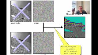
It would be a great help if you could explain the final output and what different color means.
Las referencias en colores te lo explican, si la deformación es positiva o negativa. Se hunde o se infla se entiende. Saludos
the file is read but during topsar split the polarization is not shown
Sir please help when I going to Snaphu import it's can't proceed
Hi, i have followed your steps but while trying to unwrap, the process always gets aborted after unwrapping 3 columns and shows this error message "snaphu v2.0.4
27 parameters input from file snaphu.conf (84 lines total)
Logging run-time parameters to file snaphu.log
Creating temporary directory snaphu_tiles_1413
Unwrapping tile at row 0, column 0 (pid 1414)
Unwrapping tile at row 0, column 1 (pid 1415)
Unwrapping tile at row 0, column 2 (pid 1416)
Unwrapping tile at row 0, column 3 (pid 1417)
Unexpected or abnormal exit of child process 1414
Abort
Exiting with status 1 on signal 15
Process exited with value 1
Finished tool execution in 4 seconds
Process exited with value 1
Finished tool execution in 4 seconds"
i have been trying reallly hard to find a solution for this. If anyone could help.
Can you share the configuration settings specified during snaphu export step? Also try re-running with snaphu version 1.4.2 instead
@@geovicco Tried it with version 1.4.2 as well in the command prompt window, but the error still persists.. Please help
How much time did it take on your computer to finish Computing raster data?
Because almost 4 hours gone,it still only 57% done on my os
What is the acceptable mean coherence you are applying? Also, can I change the units of displacement into millimeters using SNAP?
I would be grateful for your response.
I have used 0.2 to filter out low coherence values. You should try out a range of different values to see what suits your study area. Not sure if there's a way to change the units in SNAP itself. You can see the documentation for Phase to Displacement algorithm to see whether there is a way. If you do figure it out, kindly drop a comment as well. It will help others who have a similar question.
Thanks 😊
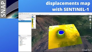
Does the displacement convey the variation of altitude from the previous date of the 2 data set used in this process??
Hello sir, i cant unwrapping
Will you please let me know, on an average how much time is required for phase unwrapping via snaphu in linux, I m using 32 GB RAM
Phase unwrapping time depends on your area of interest ie., number of bursts selected during the topsar split step. For speeding up the unwrapping process you can tweak the configuration of snaphu export function, especially the number of processors and tile size rows/columns. You can further reduce the time but subsetting the input file prior to snaphu export step. I encourage you to refer to the manual that comes with snap software for detailed info on how this process works.
Sorry there's no straightforward answer to your question for the reasons I've laid out above. For more information you can check out the esa step forum as well.
@@geovicco Thank you, sir
Is the end result in meter?
Btw thank you very much
Yes, the phase to displacement units are in meters.
@@geovicco thank you!
SNAP bisa dinstall di Linux nggak, Bos?
is this method still working using sentinel-2?
You can only use this approach with Sentinel 1 data.
Thank you so much
how to convert kml to shp?
there are several online convertors that can help you do this. try this - mygeodata.cloud/converter/kml-to-shp
I this PSI or SBAS technique
@Koigi I have yet to try that method. Could you please share any resources?
@@geovicco InSAR processing techniques include DInSAR, PSI , SBAS
PSI techniques uses persistent scatterers backscatter to produce interferograms
Halo kak, mau tanya kenapa hasil pengolahan saya pola warna citranya malah seperti pelangi ya? tidak tersebar gitu warnanya, mohon solusinya kak 🙏