
ฝัง
- เผยแพร่เมื่อ 9 ต.ค. 2024
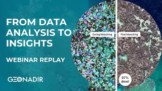
- Demo project used in the Webinar - data.geonadir....
Webinar replay which covered:
Apply contrast enhancement techniques to your drone data;
Uncover hidden details in your orthomosaics, DSMs, and DTMs;
Use enhanced data to make better decisions in environmental monitoring, urban planning, and more; and
Leverage GeoNadir's tools to streamline your workflow
Whether you're a seasoned drone mapper or just getting started, this webinar will provide practical tips to improve the quality and accuracy of your geospatial data.
RESOURCES
geonadir.com/h...
geonadir.com/m...
If you need some help, reach out to us at GeoNadir - www.geonadir.com or hello@geonadir.com

![[Webinar] ReefShape: Discover the Future of Coral Reef Monitoring](http://i.ytimg.com/vi/N4yzl1FFQcE/mqdefault.jpg)


