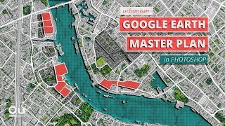
Master Plan with Google Earth and Photoshop + Animating in After Effects

ฝัง
- เผยแพร่เมื่อ 12 พ.ค. 2024
- Thanks to ConceptD for sponsoring this video! Click here to know more about the ConceptD 7 Ezel: acer.co/Upstairs_ConceptD7Ezel
―
Learn in this video how to quickly create a complex master plan using a Google Earth image and a base file.
All the digitally produced images/renderings were done using the ConceptD 7 Ezel from @ConceptDCreator.
If you need to download a base map and there’s no urban department on your contact list. Take a look at this website:
cadmapper.com/
Also, check the comment section because other people may have different options to download detailed city bases.
Learn more about ConceptD:
ConceptD 7 Ezel: ConceptD 7 Ezel
Web: conceptd.acer.com/
Social: @ConceptD | Linktree
Timestamps:
0:00 Intro
0:22 Important info
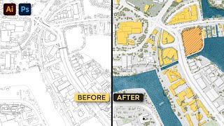
1:26 Base drawing
3:44 Site analysis (Conceptual)
4:41 Google Earth
5:40 Photoshop - First steps
8:13 Photoshop - Adding Textures
10:52 Photoshop - Highlighting areas
12:53 Animating in After Effects
―
● A platform to learn Architecture Representation and Visualization:
learnupstairs.com
● You can also follow us here:
Instagram: / learnupstairs
Facebook: / learnupstairs
Pinterest: / learnupstairs
● Let's talk:
hello@learnupstairs.com


I'd love to see you bring us more After Effects tutorials. Great job man, thanks!
Great video! I remember watching the original when it first came out! but this updated one is even better!!! Also, The animation for architecture presentation would be a really cool idea! I'm curious to see how animation comes into play in the future for young aspiring designers.
Oh! I'm obsessed! I can't wait for an After Effects video oriented to architecture
Anyone in the UK, digimaps provides many formats for many uses, free access is normally available with your University login.
That's good to know! Thanks for sharing that, Curious!
👍👍👍👍
Your original vid/tutorial of this master plan was a key inspiration for my BA thesis-project at the Royal Danish Academy of Architecture only back in January '22
Seeing you re-open it, using my capital city as the backdrop, is such a treat!
Thanks for fantastic videos mate, and for making your graphical work so readily available and easy-to-follow.. You're a godsend, thank you!
Wow your comment made my day, rahma4! It makes me really happy to know that I'm impacting people's life positively. Appreciate the kind words.
And also, what a coincidence! I picked this specific area because of the interesting urban mesh + river. Hopefully one day I can visit it!
Stay safe, cheers!
Holy crap. Best youtube tutorial I have ever seen. What a spicy workflow!
More After Effects please Oliver! You are the man!
I never thought on using after effects for architecture presentation... I would be really interesting to go deeper into it.
Nice video 👌🏼
I know right? I mean it doesn't fit in every scenario or for every type of project/client. But for a more conceptual portfolio or presentation, I feel that it'd be interesting to get creative and use AE to enhance drawings and images. Thanks, Maca Bazán Rivero!
I love your adding korean subtitles. Thanks :)
I wish this video was out during my final project development! Amazing content!!
🙌🙌
This is so great! I loved it! Thank u so much
Awesome video!!! Loved it 💙👊🏼
openstreet maps exported as SVG or PDFs when opened in Illustrator does provide you with all the necessary information just that one will have to separate the desired layers from it (when there is no other option to the information)
Great video! I am n Architecture school and I love your videos... some of the websites I use for my base fileas are cad mapper, mapbox and contour map!
Thank you for sharing, this is so helpful!
Thanks for the feedback! 😁
I can recommend Blender and its GIS addon.
The only problem for me seems to be to export into svgs. I use a outline to svg addon on top of it to export selected meshes and just add them together in illustrator
Thank you 🙏🏾
Hello there. very explanatory video, I wish videos like this to come
Great work!👌🏻🙂
Esse vídeo chegou numa ótima hora, obggg
You save my life, thank you Luv you
can you detail the export from CADMAP pr just briefly explain it ? I don't understand the process to the different png layers
You just have saved my life
thats so cool!
You can make it more complex visually if you use the stroke effect instead of trim paths, but it takes more steps. So you need to have the map and the red line on separated images. Then you create a new white solid, hide its visibility(turn off the eye icon) and use the pen tool to trace the red line. Then you apply the Stroke effect on this layer and animate the "End" property from 0% to 100%. In order to work, you have to change the track matte on the red line layer to "Alpha Matte" and the white solid layer must be above the red line layer!
It does the same thing visually as your trim paths solution, but here's the more part! If you create a new point light then you can use the mask from the white solid layer to animate the light. You just have to select the white solid layer hit the "m" key on the keyboard to reveal the mask properties and then select "mask path" and copy it! (ctrl+c on the keyboard or go to Edit---->Copy) After that select the light and hit "p" on the keyboard to reveal the position properties and select it and hit ctrl+v or Edit----> paste!
So what it does is the point light is going to follow the red path. You probably have to tweak the keyframes a bit to sync the red line reveal and the position of the light source. Now if you have Optical Flares from Videocopilot then you can use it on a new layer and then you can use the point light as the light source. It can create many interesting-looking effects. For example, a flickering flare is revealing the red line or something like that.
If you have Trapcode particular then you can use this point light as a particle emitter, you just simply need to rename the light to "emitter".It allows you to create a particle trail or something else.
I think these combinations (particle trail, flickering light/ lens flare ) can make this neat animation look even better!
Hey Tibor Miklos, that's a really in-depth comment. Thanks a lot for sharing this info!
What you're saying is a lot more complex and advanced than what I did. But my initial idea was to use Alpha Matte to reveal the highlighted area. But I thought it'd be too complex for a quick tutorial.
That's why I stuck with the Trim Paths only.
I'll try to follow your comment and process, but I can tell that you'd have taken this animation to the next level and you've got some serious moves in AE. I still got a lot to learn!
Again, appreciate your input. Cheers!
I heard of TIM online for base plans - but I think it's mostly for German locations
Great work. But in my case because of our location, we don't have detailed maps on all platforms. Could you please make a tutorial about how to import these files from GIS and basically start from scratch? Thanks a lot.
Thanks, Merve! I'm not really an expert on GIS software, I've used it a couple of times but usually with the help of professors to export base files. So I'm not sure I'd be able to teach it properly unfortunately 😓
But I understand your frustration and I'll try to look more into it to potentially incorporate it into a tutorial.
merve merhaba. buna benzer altlıkları alabileceğin bir kaç site önerisi yapan bir youtube videosu izlemiştim. Surviving Architectur kanalında 7 FREE Websites for Better Site Analysis in Architecture başlıklı video.
Hello, I work a lot with GIS but I don't prêtent to be an expert.
To answer you, you can use Qgis software (free) to import the .shape files of river, buildings, boundaries and streets.
You can also import an image and make it match correctly with the base plan! Then export a map from it, and modify it as it's done in this tutorial :)
If you need more information, I could give you some tutorials on TH-cam that explains how to do it
try snazzy maps next time, you can edit evertything! EVERYTHINGS, NAME TAGS, COLOURS, what you want or not to see... is amazing!
That’s interesting! I’ll have to take a look. Thanks!
El video es muy bueno, pero lo ideal es también comprender como lograr construir una base así de pulida como la que muestras al inicio del video, las plataformas gis son muy útiles pero hay muy pocos tutoriales para arquitectura. Sería bueno un video con ello. Un saludo
Gracias, Daniel Baron! Appreciate the feedback. I know GIS videos would've been helpful, but I'm not sure an expert in this type of software, unfortunately. 😅 And to be able to teach it, I first need to get skilled at it.
But whenever I can I'll try to bring more info about it in future videos.
I always use Digimap for base drawings. :)
worth TY
Firstly, thanks a lot for Your awesome tips! Such a valuable content you have! Really enjoying your videos while learning tons of new stuff! :)
Secondly, I'm currently approaching my Master's project presentations (in architecture field) and it would be lovely if You could make a separate video for Adobe After Effects. I really want my presentation to stand out a bit more by projecting these animations on my city scale model with a separate projector. A few tips from You would be highly appreciated
Nice)
Great! But for commercial use its usually not allowed to use Google Maps/earth images
TY
I would love some AE content for Architects
hey, does anyone know how to export as a png from cadmapper? In the past Ive used the Adobe illustrator function but it would be so much quicker to be able to export layers like he said.
best 16 minutes on youtube
Lol, got recommended this vid and I live on part of that map, thats Amager & Christianshavn, Copenhagen Denmark, I live in the lower right corner.
That’s so cool 😱
I chose Copenhagen because of the river and its urban mesh
mds tu é pfto, obrigado!
💙💙
I’m gonna explain here because in my city we don’t have the shape file of the buildings but on ArcGIS we have the possibility to get a basemap and export like a vector, of course the layers will not become in separate areas but you can join them based on color for exemplo and named them later
He said “by hand...”
Open street & Mapbox , seen from one of utube videos itself.
I love you mate
💙
how did u download these different png images with diff layer info from CADMAPPER? or did u split them in photoshop
Excelente video.! Cómo se puede hacer sin un archivo base.?
I can't get the same style of cadmapper file as your. Mine is very different. How i can fix it?
Thank you for sharing 🙏
The style doesn’t matter that much, Giorgio. As long as you have fills, it should work.
Be sure to swap stroke to fills. Select everything and hit Shift + X to swap them.
Then if you can customize each category.
I hope that helps, thanks!!
I use open street map and download in with Hot Export Tool
Is it possible to export magic wand polygons in PS as a KML to bring them back into GEP?
Como tu separou as vegetais, parks, rivers e tall?
👌
I use elk osm data through Rhino
Open Street Map for the base ?
yeah
How can I scale it once I’m done or before I start ?
Bro 💚Link to download work files ✔to apply a lesson 👍✔with you step by step and support 💙 and followed 💖
Excuse me. I want to ask why only shapes of lines download on cadmapper? There are no surface like buildings, parks.
Cool b
Does somebody know where i can get such a basemap for vienna?
This video was helpful but then it wasn’t , I followed every step but I noticed that your cad-mapper file came out with solid color areas already and mine i just plain line work …so when I go to add layers and color fill it doesn’t work the same as yours because you already have tweaked it. I love this channel but it’s kinda hard to follow as a beginner when you skip steps sometimes
Hi there! Appreciate the feedback.
Every source you download the base map will give you a different result. In the case of cadmapper it might not have fills when your download it. So covering every type of raw base maps first steps wasn’t viable.
Bases usually comes in a vector shape file, often times cad, but can also be pdf or even illustrator, so all you need to do is add fills in your preferred software.
In cad that’d be with hatches for example.
In illustrator it’s just a matter of selecting everything and hitting Shift + X. This shortcut swaps stroke to fill. (Assuming your base has closed polygons/shapes)
I’m sorry for not covering this part. I’ll improve it for next time. But from my experience even if I included it, someone would still have issues with another step.
I try to cover the most important steps and actually the ones that will help you guys the most.
Thanks a lot for the comment!
@@LearnUpstairs thank you for the extra help ! I’m learning so much from your videos for my class work , keep pushing out this great content !
Can anyone help me please regarding the base line from cadmapper? I seem to get it wrong, because there is no base on the layers, only lines
What IPad do you use? :)
Hey Hanna, I don't use an IPad. The device in this video is a ConceptD 7 Ezel, you can check the link in the description to learn more about it
how to do individuals base file on Ai?
Add a ArcGIS sever or WMTS API in GIS software,you can get the base file free ~~~
Cadmapper website does not work
I guess You've posted it before, haven't You?
Hey Janōsik, it's a similar theme, but with a lot more explanations. I said it at 0:22
This wouldnt work if you want a good graphic presentation of your project in Russia. Sadly our plans needed to be fully in 3d graphics otherwise your project is rated lower. I have my graduating exam in june and its a challenge to model all the surroundings as well
Is anyone here on Fiver that can do this for me?
I can do the same thing with Power Point in 1 min
The animation you mean, Steve?
That was just a simple example, and I know Ppt has that ability. But the thing is that AE allows you to go much deeper into advanced and complex animations, whereas in ppt your limited.
@@LearnUpstairs Yes I mean the animation
Ok I see
I'd love to see you bring us more After Effects tutorials. Great job man, thanks!