Here is the timestamps- 0:00 - Introduction 1:08 - Live Batch Announcement 2:42 - Civil 3D Interface 35:47 - Points Creation 46:16 - Co-ordination Zone Points Creation and Settings 54:04 - Convert AutoCAD Into COGO Points 56:30 - Export Points, in Excel, PDF, Text Format 58:26 - Points Tables, Create Points Groups, Edit Points Styles 1:02:33 - Live Project Site as a sample 1:11:30 - Creating Points Labels & Groups of File 1:14:21 - Contours Topographical Surface Creation 1:16:30 - Surface 3D View & Points Properties 1:20:40 - Surface Analysis, Elevation, Contours, Watershed, Slopes, Slope Arrows, Major & Minor Contours, boundaries, gridded surface, directions, catchment area etc. 1:34:24 - Surface Legend Creation, Elevation Legend, Watershed Legend, Major & Minor Contours Legends, Slopes Legends, Direction & Slope Arrows Legends 1:40:10 - Alignment Introduction, Centerline Creation as per IRC, Introduction of Curves 1:56:50 - Alignment & Centerline Terminology with Marking Details in Consideration of Curves 1:58:00 - Working with Alignment Labels, Stations Working, Chainage Properties etc 2:00:30 - Profiles Introduction, Create Surface profile, profile terminology 2:06:15 - Creating Design Profile and its terminology 2:09:05 - Profile View, Styles, Profile Properties, Horizontal & Vertical Profile Grids Settings etc 2:14:18 - Working with Assembly, Assembly Creation Tools and its terminologies 2:17:15 - Carriageway or Pavement Design with assemblies and subassemblies, kerb, sidewalk, daylight or footpath 2:11:16 - Assemblies Information and marking generation on pavement, carriageway, kerbstone, slope, daylight or embankment 2:24:22 - Corridor Creation, Working with Corridor, Horizontal, vertical baseline, stations, frequencies, corridor targets, geometric increments 2:27:50 - Corridor Surface Creation for cut & fill 2:29:12 - Highway Sign Distance analysis & its marking 2:31:50 - Sample Lines Creation, Creating Multiple Sections Lines, Creating Multiple Views and Graphs 2:35:22 - Creating Superelevation with Undivided crowned shoulder control, Attainment of Roads 2:28:22 - Superelevation Report in the Format of xmel, CSV, PDF. How to Export the superelevation report in the format 2:40:12 - Generate & Create Multiple Section Views of Highway or Roads with Complete Information 2:44:00 - Corridor Cut & Fill analysis with the volume dashboard considerations, cut & full report, generation profile editing for cut & fill 2:46:42 - Intersection Designing, Geometric Details, Corridor Regions, primary & secondary roads, transition and widening details 3:11:02 - Intersection Profile Creation Super-imposed profile creation, design profile creation for intersection, working with bands for additional information 3:15:00 - Grading Volume Analysis, Gridded Volume, Cut & Fill for small area, creation of Existing & proposed surface and surface volume calculation 3:30:25 - Profile Creation with Desired Alignment from polyline, Working with super-imposed profile and creating grades and slopes, bands for the surface profile. 3:45:15 - Railway network creation, railway tracks, geometrical design with different gauges, rail corridor creations. 3:57:27 - Roundabout or circulatory design, entry roads, fastest path analysis, visibility analysis, corridor, signage, Road markings 4:11:00 - Animation & walkthrough of highway with complete topographical surface
Thank you for supporting💝 PTS CAD EXPERT, Keep supporting us & 😍Do LIKE & Subscribe to our Channel Civil 3D Advance Live Course with Google Earth & Global Mapper - web.ptscadexpert.com/new-courses/43 100 GB 3DS MAX Components for Interior Design & Exterior Elevation - imojo.in/4irfaw9 Download premium Components - www.instamojo.com/PTSCADEXPERT/?ref=profile_bar Download 1000 AutoCAD Drawings - www.instamojo.com/PTSCADEXPERT/1000-autocad-plans-with-standard-dimendions/?ref=store
Hi I like your teaching style. How to take civil 3d course from you. I am a civil engineer. I have software experience in Revit and AutoCAD only. Now I want to learn civil 3d and other latest software also. So, can you please guide me?
Hello Mr. Vijay Chauhan, By the way these files are confidential but apart from this you will also get many files in the live session. A complete format of this will also be shared with you.
Hello, Sir. This is such an amazing learning video! But can you upload all the supporter files such as points? I think nobody could learn this video without it. Thanks in advance
thanks for your appreciation ❤ , All these are some data of confidential projects, which we cannot share like this, but in live session or training, we make some minor changes in these data and practice them for better results.
Hello Mr. Qasid Elahi, all these are some data of confidential projects, which we cannot share like this, but in live session or training, we make some minor changes in these data and practice them for better results.
Hello Mr. Yashas Sindhe, By the way these files are confidential but apart from this, you will also get many files in the live session. A complete format of this will also be shared with you.


Here is the timestamps-
0:00 - Introduction
1:08 - Live Batch Announcement
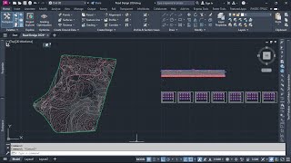
2:42 - Civil 3D Interface
35:47 - Points Creation
46:16 - Co-ordination Zone Points Creation and Settings
54:04 - Convert AutoCAD Into COGO Points
56:30 - Export Points, in Excel, PDF, Text Format
58:26 - Points Tables, Create Points Groups, Edit Points Styles
1:02:33 - Live Project Site as a sample
1:11:30 - Creating Points Labels & Groups of File
1:14:21 - Contours Topographical Surface Creation
1:16:30 - Surface 3D View & Points Properties
1:20:40 - Surface Analysis, Elevation, Contours, Watershed, Slopes, Slope Arrows, Major & Minor Contours, boundaries, gridded surface, directions, catchment area etc.
1:34:24 - Surface Legend Creation, Elevation Legend, Watershed Legend, Major & Minor Contours Legends, Slopes Legends, Direction & Slope Arrows Legends
1:40:10 - Alignment Introduction, Centerline Creation as per IRC, Introduction of Curves
1:56:50 - Alignment & Centerline Terminology with Marking Details in Consideration of Curves
1:58:00 - Working with Alignment Labels, Stations Working, Chainage Properties etc
2:00:30 - Profiles Introduction, Create Surface profile, profile terminology
2:06:15 - Creating Design Profile and its terminology
2:09:05 - Profile View, Styles, Profile Properties, Horizontal & Vertical Profile Grids Settings etc
2:14:18 - Working with Assembly, Assembly Creation Tools and its terminologies
2:17:15 - Carriageway or Pavement Design with assemblies and subassemblies, kerb, sidewalk, daylight or footpath
2:11:16 - Assemblies Information and marking generation on pavement, carriageway, kerbstone, slope, daylight or embankment
2:24:22 - Corridor Creation, Working with Corridor, Horizontal, vertical baseline, stations, frequencies, corridor targets, geometric increments
2:27:50 - Corridor Surface Creation for cut & fill
2:29:12 - Highway Sign Distance analysis & its marking
2:31:50 - Sample Lines Creation, Creating Multiple Sections Lines, Creating Multiple Views and Graphs
2:35:22 - Creating Superelevation with Undivided crowned shoulder control, Attainment of Roads
2:28:22 - Superelevation Report in the Format of xmel, CSV, PDF. How to Export the superelevation report in the format
2:40:12 - Generate & Create Multiple Section Views of Highway or Roads with Complete Information
2:44:00 - Corridor Cut & Fill analysis with the volume dashboard considerations, cut & full report, generation profile editing for cut & fill
2:46:42 - Intersection Designing, Geometric Details, Corridor Regions, primary & secondary roads, transition and widening details
3:11:02 - Intersection Profile Creation Super-imposed profile creation, design profile creation for intersection, working with bands for additional information
3:15:00 - Grading Volume Analysis, Gridded Volume, Cut & Fill for small area, creation of Existing & proposed surface and surface volume calculation
3:30:25 - Profile Creation with Desired Alignment from polyline, Working with super-imposed profile and creating grades and slopes, bands for the surface profile.
3:45:15 - Railway network creation, railway tracks, geometrical design with different gauges, rail corridor creations.
3:57:27 - Roundabout or circulatory design, entry roads, fastest path analysis, visibility analysis, corridor, signage, Road markings
4:11:00 - Animation & walkthrough of highway with complete topographical surface
Thank you for supporting💝 PTS CAD EXPERT, Keep supporting us & 😍Do LIKE & Subscribe to our Channel
Civil 3D Advance Live Course with Google Earth & Global Mapper - web.ptscadexpert.com/new-courses/43
100 GB 3DS MAX Components for Interior Design & Exterior Elevation - imojo.in/4irfaw9
Download premium Components - www.instamojo.com/PTSCADEXPERT/?ref=profile_bar
Download 1000 AutoCAD Drawings - www.instamojo.com/PTSCADEXPERT/1000-autocad-plans-with-standard-dimendions/?ref=store
I have seen a number of online platforms but all are good but pts is best of all thank you soo much
most welcome & thank you so much
sir thanku so much for the good content , i am in love with pts cad expert
thank you so much
I like your videos. But some of us don't understand indian language. Am requesting you to use English so that we all understand what you are doing
And also for Revit kindly do us videos in English we are really struggling out here. Thanks
Your videos are so helpful for me and for all very clear very simple way I appreciate you all the time
very very help full video sir
thank you so much
Thank you so much Mr. Rinku Kumar ❤️
If it's tamil really helpful
Hello SIR! Kindly do us the same for Civil 3D full course in these 3 videos in English and we will appreciate please! Thank you
great video sir very helpfull
thank you so much
Thank you so much Mr. Nigam Yadav ❤️
Thank u for posting this video, sir
You're welcome Bhargav Rathod
Please do the English version. Lot of young engineers need your expert training
Sure MELBET, definitely we will work on this version also.
@@er.anandsharma thanks
Sir, can you provide survey data, we can not practice this without this data.
Thank you.
same if you have found the data please with me
THANK YOU THANK YOU SO MUCH SIR FOR THIS VIDEO
You're welcome Mr. Anurag Gaur ❤️
Very Helpful .....thank you
sir ager main ye course join kru to kya main highway design puri shikh skunga
of course
Absolutely you can learn complete highway design like a professional
dear sir,pls a video regarding Stone retaining Wall design with procedure pls
Hi
I like your teaching style. How to take civil 3d course from you. I am a civil engineer. I have software experience in Revit and AutoCAD only. Now I want to learn civil 3d and other latest software also. So, can you please guide me?
Sir please provide data which are required, without data it's not possible to do practice and also not able to complete full course
sure, which type of files do you required
Hello Mr. Vijay Chauhan, By the way these files are confidential but apart from this you will also get many files in the live session. A complete format of this will also be shared with you.
@@er.anandsharma sir please just share the files which are used in this video without changing files's format .
Share the files
sir live class kab se start hoga of civil 3d plz let me knw
Today onwards we have started the batch
Hello Mr. Yogesh Mondal, if you want to learn Professional Civil 3D then you can join live session from Monday also.
Hello, Sir. This is such an amazing learning video! But can you upload all the supporter files such as points? I think nobody could learn this video without it. Thanks in advance
thanks for your appreciation ❤ , All these are some data of confidential projects, which we cannot share like this, but in live session or training, we make some minor changes in these data and practice them for better results.
@@er.anandsharma the video on this channel should be REMOVED. IT's USELESS
th-cam.com/video/YTvOCtFqNH8/w-d-xo.html
Sir kindly jis data per video ho wo data b description mein add kr dia krain, kindly ye data dal dain
Hello Mr. Qasid Elahi, all these are some data of confidential projects, which we cannot share like this, but in live session or training, we make some minor changes in these data and practice them for better results.
Sir g civil 3d software purchase kese kare plz bta dijiye
very helpful ..........
Would be nice if same material was available in English, just saying.
please check the subtitle
SIR MERE MODEL ME GRID SHOW NHI HO RHA HAI
Class time kya hoga
Hello Mr. A Kumar, Evening batches are available
For more details what's app @ 81999-29888
i have language problem. can it learn in english or telugu
How to get points for civil 3d project practice
Didn't you find the point file
No pts ...how can find ?
can i gat the serving file discuss in the previous video
which files
Please share the video name or link
after that i will tell you about the file
I want to take live class
Is there any option to buy the course from Bangladesh?
Kindly contact to our team at 81999-29888
Sir my station point is looking same as simple point why?
Sir auto cad 3d download kese kare
Brother, Can you share Theodolite data file???
PLS PROVIDE SURVEY DATA FOR PRACTICE
if you have found share with me
Hi this is JILAN from hyd can u provide online training
Hello Jelan Basha, ofcourse we provide online training.
install our mobile application "PTS CAD EXPERT" From Playstore
Sir is vedio me jo file use huaa hai o kaha se milega
if you have found please share with me
Sir please provide data for practice
Make videos in English please.
Sir, please provide data and file related this video.
SIR IS VIDIO KI SURVEY FILE 1299 POINT KI CHAYE PLZ SENT ME ...
Please share theodolite data
th-cam.com/video/YTvOCtFqNH8/w-d-xo.html
Pls i need the survey points
Sir give me excel file for practice
Subtitle indonesia please!!!
please try to translate the subtitle in english for non indians
sure, w'll do in the next video
Please provide the files
Hello Mr. Yashas Sindhe, By the way these files are confidential but apart from this, you will also get many files in the live session. A complete format of this will also be shared with you.
Man lo.. Man lejiye toomany times.
In English please
Ye sub ka future 0.0 hy 😂