
ฝัง
- เผยแพร่เมื่อ 10 ต.ค. 2024
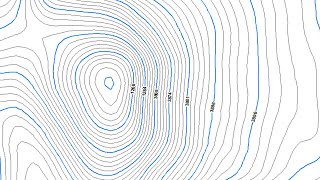
- Modeling data from terestrial surveys using GPS Geodetik Hi-Target v30
Please like, share and subscribe this channel 🙏🙏🙏
Watch other ArcGis Tutorial videos 👇
How to add basemap in Arcgis 10.8
• How to add basemap in ...
How To Georefrencing Image Google Earth in Arcgis 10.8
• How To Georeference Go...
How to Download and Install ArcGis Pro 2.8
• How To Georeference Go...
How to Download and Install ArcGis Pro 2.8
• Video
How To Download and Install Arcgis 10.8
• Video
How To Download and install ArcGIS 10.7.1
• Video
How To Composite Band Landsat 8 in ArcGIS 10.7.1
• Video
ArcGis 10.7.1: Create Contour DEM & 3D From Google Earth
• How To Create Contour ...
How To Calculate Area and Perimeter In ArcGis
• Video
How to Create Animation Flood In ArcGis
• Video
How To Create Watershed In ArcGIS 10.7.1
• How To Create Watershe...
HowTo Download Sentinel Image From Esa And Create DEM
• HowTo Download Sentine...
How to Import Garmin GPS Data Using DNRGarmin In ArcGis
• Video
How to Create Bathymetry Maps In Arcgis
• How to Create Bathymet...
How To Create Contour from Excel In ArcGis
• How To Create Contour ...
How To Create Orthomosaic from Drone Images In Arcgis
• How To Create Orthomo...
How to Create Sea Surface Temperature In ArcGis
• How to Create Sea Surf...
How To Download SRTM Maps From USGS , Create Contours In Arcgis
• How To Download SRTM M...
#omzepro#outdooractivity#GIS#surveyandmapping
#arcgis#qgis#gistutorial#qgistutorial#arcgistutorial


What about coordinate projection? If I want to use this contour with some other data which is already georeferenced