Why was this Sea in North America on Old Maps?

ฝัง
- เผยแพร่เมื่อ 28 ก.ค. 2024
- Here is yet another giant body of water on old maps of North America that turned out not to exist. I’ve covered a few others and they are all associated with the wish to find a quick passage to Asia but each has its own unique backstory.
RareMaps.com Sources
----------
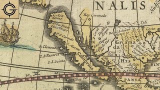
Guillaume De L'Isle / Jean-Claude Dezauche 1783 - www.raremaps.com/gallery/deta...
Philippe Buache 1780 - www.raremaps.com/gallery/deta...
Guillaume De L'Isle / Philippe Buache 1763 - www.raremaps.com/gallery/deta...
Louis Jolliet 1689 - www.raremaps.com/gallery/deta...
Other Internet Sources
--------------
www.oldworldauctions.com/info...
antiqueprintsblog.blogspot.com...
sea-of-the-west.info/title
www.biographi.ca/en/bio/fonte_...
collections.britishart.yale.e...
Book Sources
-----------
The Phantom Atlas by Edward Brooke-Hitching
French Translations - Kevin Mallet
Social Media
------------------------
Map Shop - thegeographygeek.com/
Instagram - / thegeographygeek
Patreon - / geographygeek
Email Newsletter - eepurl.com/hSeKpj


Thank you RareMaps.com for supporting another video! Their maps and descriptions are a huge part of the research and visuals that go in these videos. You can purchase your own map with the Sea of the West from their website. - RareMaps.com/
Bless your heart for thinking i'd have $5000 just laying around to buy old maps with.
@@Thingsyourollup some are less than $200
Are you SURE that that sea never existed? There is now belief that there was a huge lake out in that area. From Missoula, Montana to the coast. It was a remnant of the last Ice Age. To my understanding, they do not know when the dam broke, but the lake did exixt.
@@lourias I believe that multiple stories got combined into one and this depiction is how the De L’Isle family interpreted them. Could have been Great Salt Lake, Puget Sound, the Pacific Ocean, maybe some other bodies of water all combined into one. Plus there was a bit of wishful thinking involved. Every inland sea I’ve covered involved the map maker interpreting what they heard as exactly what they wanted to hear.
Edit: spelling
@@GeographyGeek My apologies, I wrote a strikingly similar comment before I saw yours. Great minds think alike?🙂
It sounds like a bunch of Europeans heard some stories about the Puget Sound, the Great Salt Lake, and few rivers and started making up oceans again.
I feel the same. A lot of stories merged into one with a bit of wishful thinking sprinkled in.
Because the French wanted to believe there was a great inland sea, that's how what they heard. It's possible that the natives were referring to the Great Lakes which were further east, and the French thought they were talking about something in the west.
North Central California was a massive seasonal lake back then as well. It’s since been eliminated and the water diverted by a massive system dams and canals. “Cadillac Desert” is a phenomenal history of water management in the western USA and covers this
Number one, the puget sound doesn't stink, number two, the now dried up Tulare lake is better positioned to be the sea of the west. Also it had no outlet, so i imagine it smelled a bit like the Salton sea... not good
Also the name you're looking for is the Salish sea, and by no means is it an "inland" sea, nor can it be reached by river.
I live further north of the supposed lake. Geologically this area was part of a vast inland sea in prehistoric times. I wonder if the First Nations oral traditions were referencing remains of that body of water when they migrated through northwestern North America?
They called it a "sinking sea"! One that would raise and lower to allow crossing actually makes a lot of sense here. However, other natives specifically said it's only a 8 or 15-day journey, and that they go there to trade with the bald peoples. Sort of not helping this hypothesis
The sea you're talking about existed in N America 100 mil years ago, so looooong before ANY humans existed
@@RomaInvicta202 100 million years ago i bet north america wouldnt be recognizable due to plate tectonics so i bet lots of things would be different
@@neiro314 I suggest you go and read about it, then you won't have "to bet" - science is not gambling
@@RomaInvicta202 weird angle to take but okay
Sounds like this western sea could be an exaggeration of Puget Sound, the Strait of Juan De Fuca, and the Strait of Georgia, known collectively as the Salish Sea. So in a way this inland western sea does exist it’s just they over estimated it’s size quite preposterously. The Salish Sea does seem quite large while standing on its shores.
seems plausible to me
Looks like the river to the south that goes to the sea would be the Columbia.
Or there was the all mother of god winter/snow/rain in those years which could've swelled the water to new heights. But a couple day's ride in a small boat ? even with this scenario it's not really probable. who knows !
The description of the sea from the Sioux in New Mexico as a 'great lake' with 'stinking water' almost certainly refers to the Great Salt Lake. The explorers heard stories from all over Canada and the Western US about notable nearby bodies of water that the locals referred to as 'large' and 'to the West' and instead of realizing that these could be different bodies of water assumed it was a vast inland gulf that stretched from Colorado to the Northwest Territories, which, somehow, they had simply never found.
Its half a video, lazy.
Others have noted various aspects of this, but I think a strong case could be argued for the native accounts to have been referring to Lake Bonneville... which survives today as the much smaller Great Salt Lake of Utah. The description of a stinking salt sea fits like nothing else in the region, and the area aligns fairly well with Bonneville's historic location. It seems reasonable that people living far away would continue to tell stories of the size of the lake at its height rather than its (then) modern size.
its pretty huge, and was even bigger a couple centuries ago. Not sure the natives ever described it to be as big as some of those maps have it, probably because they conflated it with SF Bay or pugeot sound.
Like Conrad said, I think the stinking description is the dead give away
1000 years ago it was 20,000 miles in size.
Im almost certain they conflated the great salt lake and the puget sound as one big body of water because they had no concept of the scale of either, having never seen them
Highly plausible in my opinion, not that it’s worth much lol
if you look at the old map, you can see that none of the currently existing lakes are actually mentioned. I can only imagine that perhaps they were alot more connected back then and considered 1 large lake, instead of several lakes.
I left my own thoughts out of this video so I’ll put them here. The Sea of the West in the form you see on the maps definitely didn’t exist. The topography and geological history of the region just don’t support it. With that being said I think there is a small bit of truth to it. Just as the Sea of Verrazano turned out to be a sighting of Pamlico Sound, the Appalachian Salt Lake may have been native references to the Great Lakes, the Sea of the West may have been combined stories of the Great Salt Lake, the Pacific Ocean, Puget Sound, and maybe other bodies of water but the final ingredient was wishful thinking by Europeans just like the other seas. In retrospect, I’m not sure why I left that part out of the video when I included it in the others.
Edit: I added some more information and my thoughts on the Sea of the West in another video on my personal channel - th-cam.com/video/8ssJRX4jjUM/w-d-xo.html
This is what I was looking for. I was thinking it could be the Great Salt Lake. But I'm not sure about the Great Lakes. The Europeans would have known about the Great Lakes. I think they would have attempted to rule them out when speaking with the natives.
I'm not sure that would have been successful. Considering how badly they wanted to believe in The Sea of the West. But I'm fairly sure they would have tried to make sure they weren't talking about those lakes. Maybe by mentioning salt?
@@Kahless_the_Unforgettable The Great Lakes reference was for the Appalachian Salt Lake not the Sea of the West.
th-cam.com/video/J-DaWQV3pxw/w-d-xo.html
Yes, it would make perfect sense that the "sea" the natives were referencing was the Great Salt Lake. Map making was not all that accurate back then.
@@tauron1 maps were pretty accurate then when it came to parts actually surveyed but the Sea of the West was theoretical which viewers at the time would have known.
@@GeographyGeek most of the maps were somewhat accurate, I guess for that time they would be considered very accurate, however when it came to this hypothetical sea, most of the information was gleaned from the Native population who mentioned a sea to the west. Now unless you are considering that they were speaking about the Pacific Ocean, then it would stand to reason they in reality meant the Great Salt Lake as that is the only sizable body of water west of the Mississippi. Now as for the placement of said "Sea" on the map, location, size and orientation of land masses and bodies of water on ancient maps were rarely accurate. Interesting topic for sure, I enjoy looking at ancient maps, as I get a real chuckle and at times amazement on what peoples from long ago thought. btw, the Great Salt Lake would also be far larger that back then, than it ever was in the early 19th century when people started to settle in the area.
I wonder if we could start a new society, like the Flat Earth Society; a "Sea of the West Society". We will uphold the existence of this body of water, denounce anyone who says otherwise, propose a vast conspiracy to conceal it from modern maps, and hold regular appreciation meetings dedicated to restoring it to modern maps! No one from British Columbia will be allowed in the club, of course.
I’m down
Flat Earth Society is a controlled opposition
I'm in, down with the government conspiracy,and the province of British Columbia! You can't keep the Sea of the west from the world any longer!!
Am from Banff, can confirm there is a large inland sea between the Canadian Rockies and Vancouver.
@@truenorthstrongfree salt lake is a Sea
There are rumored to be quite a few Spanish explorations in the two hundred years between Juan de Fuca in 1592 and Juan Perez in 1774 that were kept secret by the Spanish crown. Its no surprise that Straight of Juan de Fuca and the Columbia River mouth are charted accurately before their official discovery. I've sailed the Straight of Juan de Fuca and it feels enormous, two distant mountainous landmasses on either side makes it seem like youre entering a gate, and once you get to about present day Victoria BC, there are opportunities for sailing in any direction. If you went no further and the weather was like it usually is around here, you might be mistaken you are in an endless archipelago. I'm guessing the French reinforced their idea of an inland sea with the Spanish accounts of the entrances they saw along the coast.
This seems like the most likely explanation.
“Lake Bonneville was the largest Late Pleistocene paleolake in the Great Basin of western North America. It was a pluvial lake that formed in response to an increase in precipitation and a decrease in evaporation as a result of cooler temperatures. The lake covered much of what is now western Utah and at its highest level extended into present-day Idaho and Nevada. Many other hydrographically closed basins in the Great Basin contained expanded lakes during the Late Pleistocene, including Lake Lahontan in northwestern Nevada”- Wikipedia
No one else is mentioning that. It is most likely that it was lake Bonneville, combined with a few other bodies of water, perhaps due to lack of exploration they didn't map it correctly
The great salt lake is the reminants of lake Bonneville you can see where the shoreline used to be about half way up the 10 to 12 k ft high mountains both east and west of SLC. To the west it looks like it was more beach like how the ocean shoreline is.
_"Lake Bonneville was the largest Late Pleistocene paleolake in the Great Basin of western North America. It was a pluvial lake that formed in response to an increase in precipitation and a decrease in evaporation as a result of cooler temperatures. The lake covered much of what is now western Utah and at its highest level extended into present-day Idaho and Nevada."_
You could at least _try_ to not straight up copy paste off of Wikipedia without citing source lol. Jesus...
Disregarding this blatant attempt at sounding smart, you're right, and Josia Hall is right, except this lake existed 11 000 years ago and what is more likely is that they were referring to a collection of lakes which were already MASSIVE and _extremely_ hard to map properly without a *LOT* of work. There may also be circumstances we don't know about, like floods or even a tsunami.
The rivers does run all the way to the coast and the "fjord" (inlet) does exist. Also a salt lake doesn't magically appear without being connected to the sea at one point.
@@SebHaarfagre , close - Bonneville was at its height in the very early Holocene. And it continued to exist for thousands of years, dwindling slowly. In a sense, it still exists as the Great Salt Lake. It’s not surprising that many Native American tribes remembered it via oral tradition, and assumed it must still be there.
@SebSk it has quotations and says wikipedia at the end.
The Map at 5:35 describes Juan de Fuca's Corridor. According to this map, at least, the Western Bay seems to be an Optimistic Projection of Puget Sound and Vancouver Bay. Probably also confounded with the Great Salk Lake and the San Francisco Bay through MisTranslation. Wishful thinking that Juan de Fuca, San Francisco Bay and Great Salt Lake were all the same thing
I've lived on Vancouver Island - these maps do seem like a distorted retelling of the straight and bay.
If Juan de Fuca actually discovered San Francisco Bay, then it probably wasn't fear of attacks by the natives that drove him off, but rather the price of housing....
Lake Bonneville was a thing too. Covered the majority of Utah and went into idaho
You do realize there was once a giant lake called "Lake Missoula" that existed some 13,000 years ago that was held back by an ice-dam which repeatedly broke and reformed as the ice age receded. It existed as a combined ice sheet and southern lake that nearly precisely fits in the area of the lake you show in this video. Lake Missoula occupied a great deal of area in Montana, rivaling or exceeding the Great Lakes further east in terms of size and water volume. Much of Oregon and Washington were scoured by water released from this dam break in disasters with water up to 600 feet high, traces of which are still easy to see on the landscape. Undoubtedly, Native Americans likely witnessed these events and recorded it in their legends. This occurred some 20 to 25 times with these floods happening over the course of several centuries. These events are likely the source of the legends with the various native American tribes, all of which likely heard about the multiple disasters in the Pacific Northwest during that era. You should do another video to share the maps that show the lake as it was and talk about the nature of the disasters that befell Oregon and Washington State because of that lake's violent water releases.
Yes. The people remembered and passed down the history. Then I suppose more modern people who had never been there or seen it (being so far in the past) just retold the history to the Europeans as current fact. Oral history has been proven to be more enduring and acurrate than written history.
@@1ACL Absolutely correct - Thanks for the nice comment!
Those dates are very flexible. When it comes to prehistoric America anything from 3,000 years ago to 10,000 years ago is plausible for much native stuff. That would allow for the lake to still be there within the time that the ancestors of the current native tribes might have come. They may also have heard it from the Clovis people that came earlier.
Thanks for saving me 8+ mins of my life
I think it's just the salish. he mentions between 47 and 48 latitude, west coast, big bit of water, all signs point to the salish sea. they were just confused about the scale of it
Fascinating, thank you. It’s possible that the European explorers conflated the natives’ accounts of two different seas, the Great Salt Lake and the Strait of Juan de Fuca. “Eight days ride” from the Southwestern US, and “stinking water” sounds much more like the Great Salt Lake to me. I believe that the natives were perfectly accurate, and it’s the Europeans who made the goof, considering the language barrier. There’s also an element if wishful thinking present, as in the famous, non-existent, Northwest Passage.
Following recent climate change and global warming, the high Artic has been afforded the most, resulting in merchant shipping now being able to traverse from the Pacific to the Atlantic Ocean via the Bearing Strait the Artic Ocean and the Labrador Sea during the summer months. ie: The Northwest Passage.
Similarly, merchant shipping can now traverse between Archangel and Vladivostok across northern Russia/Siberia during the summer months. Ex-Soviet era nuclear powered Ice Breakers maintain this Artic sea route all summer.
What on Earth are you talking about? The Northwest Passage is a very real and tangible thing.
@@SebHaarfagre calm ya tits, they are referring in the northwest “inland” passage. Not the one that goes the Atlantic and pacific through the Arctic. Don’t be getting angry on TH-cam.
Another possibility - the area around Sacramento CA ("Central valley"?) has had a lake in it at times.
@@adriancarter2863 Indeed! There is a Northwest Passage. They were just looking at it too early, before we got the current level of climate change. It'll be open longer as the earth warms.
Oh, nevermind that the global warming will cause far more problems than it will solve!
I have often looked at maps of the San Francisco bay and wondered if the entire central valley was once part of the bay. Even now it is barely above sea-level, so at one time it may have been lower and filled with a vast shallow lake. On some of the maps you can almost see where the Golden Gate Bridge would span its mouth. In addition the central valley has very rich soil that could have once been a seabed. Maybe tectonic action uplifted it and drained it.
It’s not that serious bro bodies of water just simply dry up like what are you people not understanding?
You are correct- that exact water was a seasonal NORM from north of Sacramento to Bakersfield and much of the current SF Bay Delta borders are landfill or levee reclaiming rather than the much wider waters that as recently as the 1920s had year round boat passage to Tulare Lake at the south end of the Valley- it being visible from space it was so huge before it was drained and the future winter runoff channeled to the LA basin and arid upper farming zones.
that valley has been a sea, a lake, a giant swamp, and sorta dry land at various times throughout history, you can look this up, there's plenty of research, stanford is right there. thoughout the history of the earth, not human history that is.
Lake Tulare came back
It was indeed a lake, known as Lake Corcoran. It filled much of the Central Valley basin, and eventually drained into the San Francisco bay as you described. It also likely drained to the south, as well. Corcoran existed about 700kya (700,000 years ago) and left behind many large lakes in California, such as the (in)famous Tulare Lake.
I watched an episode of Nova years ago that was about a geologist , from the 1880's, who thought all the canyons were carved out by large lakes emptying out catastrophically over the land. After watching this im wondering if those events were more recent than imagined.
Genesis is history, not fairy tale
Look into geologist Randy Carlson . He's done a lot of study of the American northwest and how so much of it was carved out and eroded from massive flows of water
Massive natural dams broke hundreds of years after the Genesis flood when the ice age ended. This is how Grand Canyon was formed.
Fascinating that there are old maps depicting things that either never existed, or shouldn't have even been possible to know when first created. I've been captivated by such information since learning that there were cultures that knew the world was round well before the decision was made that it was flat, yet maps from earlier times showed otherwise. There was a great deal of history lost over time, and rediscovering such knowledge is just amazing. In this case, I'd imagine there was some 'word of mouth' knowledge passed down through generations, within the indigenous tribes of North America. It was likely the Puget Sound that was spoken of, and mistaken as what was included in such maps of the time. That doesn't discourage learning about other such depictions of the 'lost known world', at least for me. I still think many of those old oral history items hold a great deal more about the past then given credit for.
You can still see lake Bonneville shore line today in Utah
I added some more information and my thoughts on the Sea of the West in another video - th-cam.com/video/8ssJRX4jjUM/w-d-xo.html
The Hudson Bay Company in Canada with Trading Posts and Fur Trappers chasing beaver pelts, were some of the earliest explorers of
N America, but they went west much further north in Canada.
The qu in Vasquez makes a sk sound. It's like Vaskez. Great video!
Ahhh I appreciate it!
Videos like this are EXACTLY why I watch history TH-cam. Making full use of the medium, and seeming very well researched.
I appreciate it!
Saw my first video from you about a week ago or something and now I'm hooked! Your explanations and research are super easy to understand and follow, such an awesome channel!
I really appreciate that!
@@GeographyGeek why is Cali not an island 🏝️😮?
Up here in Montana, we have a museum that has maps and claims the Pacific Ocean once came into Canada in the same area. It continued into Montana, connecting to the now Missouri River and taking up most of the eastern half of the state. It then connected to the Mississippi and went all the way down to the Gulf.
That's correct Nicky and I live near Great Falls and find sea shells, although small when I hike across what are now wheat fields .
some of the depictions of the map show a sea in the shape of California’s Central Valley. It makes me wonder if this unknown Lake is Tulare Lake (or it was part of it), which was the largest freshwater lake west of the Mississippi till it dried up in the late 1800s. I live just miles away from where Tulare Lake once was and found this video very interesting.
th-cam.com/video/VxCbjEoJxj0/w-d-xo.html seems to agree with you, macadelic
There once was a massive lake in California named Lake Tulare. It’s water was diverted for irrigation purposes and is now gone.
I love how in maps of that time period the east coast is impressively close to reality but the further west you go the crazier it gets.
I love your research and channel ❤
Hey I really appreciate that!
Lake Tulare in the central valley of California was recorded to be 26 miles wide and over 200 miles long in the 1800s. Today it's a small lake in Tulare, it was by reduced irrigation done at the turn of the century.
Exactly big bodies of water, sometimes simply just dry up. And sometimes floods happen and make new bodies of water. Has nothing to do with tectonic plates, or if people were making of regions or whatever.
Yep and more than likely connected to San Francisco Bay
@@777Poker True and California has lots of seismic activity.
@@joesmoe282000 scientists claim that there was a body of water much larger known by geologists as lake Concord and the remains of prehistoric manatees have been found as far south as Bakersfield.
Thank you so much for your expertise and I hope you have a wonderful week ahead 🌎
Thank you! You too!
cool that you worked your ad into the fabric of the video and used rare maps as a resource. i bet they appreciated it too lol
So...No mention of San Francisco Bay, nor the Great Salt Lake. There once was a 'great inland sea', but it has largely disappeared, leaving a huge salt pan.
Lake Bonneville!
Salish Sea is pretty big if you go from the top of Vancouver Island down to Olympia, Wa
It's almost certainly the inspiration for this Western Sea.
TH-cam just recommended this video and I'm sn instant subscriber. This channel is so cool!!
i love this channel sm
I can understand how the idea might have started. The geogia straits and puget sound area, known to the natives in the area as the salish sea, are 650km from olympia to the north end of Vancouver island, and the main outlet is almost 48 degrees north
Yes, the western United States used to have massive lakes, such as Lake Corcoran in California's Central Valley (that left behind Lake Tulare after drying up), Lake Bonneville in Utah (that left behind the Great Salt Lake after drying up), Lake Lahontan in Nevada (that left behind Pyramid Lake), and Lake Missoula in Montana.
Corcoran drained out hundreds of thousands of years ago, but the last three did exist until about 13kya (13,000 years ago). As far as we currently know, that time frame does allow for migrating people into western North America (starting around 15kya-25kya) to have discovered them, but they would not have lasted long at all and certainly were mostly dried up by the 17th-19th centuries.
What a superb sponsor integration, it fits perfectly with the video and the video shows why such a thing is actually pretty cool. Bravo
I appreciate it. I really like having them as a sponsor because of that.
Great video; thanks for posting.
It rains a _lot_ where I live, near Vancouver. Sometimes as much as in the Amazon. There's a major river, a large network of lesser rivers, countless little creeks and tributaries of all types. Lots of runoff from glacier melt every year. Rain all spring, a month or three of sunshine, rain all autumn, and rain all winter (except when it's snowing). Rain almost every day, every morning, every evening, every night. Very wet.
The puddles can get pretty deep. The ocean is right next door. But I don't think I live in a sea.
I live in Spokane Washington and I have been down The Columbia to Puget Sound. The Columbia is huge! I could easily see how the early explorers could think there was an inland sea north of it.
Could this have been the great California Inland Sea? All that was historically a big sea connected to the ocean around San Francisco. Not sure there was anything left but a few scattered lakes by that time, but wonder if it was in their ancestral lore. I keep hearing that with oceans rising, that its a real possibility that this inland ocean could return.
Our weatger cycle has returned rains that have all but recreated the smaller version of Tulare Lake this year- and snowmelt from the epic snowfalls over 4k feet hasn't even happened yet.
Desperately reinforced levees are the only reason the entire south end of the CV isn't filled in a shallow lake today, particularly since the subsidence there is 30'40' lower than when it WAS a lake in the 1920s.
The upper San Joaquin portion has big chunks of reclaimed delta just basically swamped most weeks for the last couple months, and the very wide northern river natural floodplains are waterlogged too.
No need for any oceans to rise- if we didn't funnel so much fresh water out to LA and levee so much land it would still be possible to take a ship from SF to Chico north and Bakersfield south.
Surprising this guy doesn't even Mention this in his Video shows you the lack of research . But the great California Inland Sea was a Fresh Water Sea . And only contained to the Sacramento Valley. What we call The 4 Great Rivers Sacramento, American, San Joaquin and Feather rivers would flood the Whole Valley From Red Bluff all the way to Baskers field. The Inland Sea and wetlands would still exist today but all 3 of those rivers are dammed up.
Thank you for the info in this video!
Btw, I noticed that in all the maps, I could see Baja California that this peninsula was drawn connected to the continent. One video I've seen told a story that it was once a separate island.
As a resident of Salt Lake City, I knew exactly what the source of the native stories would be. Especially when the Sioux mentioned the "stinking waters." After 150 years of human dumping things into it, those waters stink even worse now.
It’s also salty while most lakes are fresh water, which is why they thought it was a sea. Just a thought.
Yeah sounds right to me to. Never been to(nor smelled) the great salt lake though, but I like to think it may be stinky. God bless brother!
@@mikewabrown1052 The stinking is always the worst in the summer when the lake levels drop and the algae gets exposed and rots.
Basically, there was a conspiracy in the cartographer/seafarer community to keep up the kings' hopes for a northwest passage. This ensured continued funding for their jobs. If they were to flat out admit that a northwest passage wasn't feasible, they would be out of work!
the people could not believe how far north the Northwest Passage is, but I am sure there was a history of using it back in the warm times. How nice the weather must have been then.
And no way that could ever happen today in this day and age.
_>
Yes, seems clear now that this is the Juan deFuca Straight (finding that entrance, and seeing the Strait of Georgia the north, and Puget Sound, to the south. but no one ever going up or down into either; and below it, the navigable Columbia River... Cool.
Interesting discussion and I love maps.
I live in Montana and I often find miniature sea 🐚 shells in the wind blown areas of the Great Plains. So there truly was an Inland sea here , albeit in prehistoric time.
That's the part that doesn't make sense to me, for the sea to have been over the great plans it would mean some major natural disaster would've had to occur for the sea to dry up in the time span of 1500 to 1750
@@nickzalan4762 did you not hear the part about “prehistoric times”? There hasn’t been a sea there for millions of years.
Lake Missoula existed as recently as 13,000 years ago. It covered much of Washington, Idaho and Montana. It was created by glaciers of the last ice age.
I wonder if cartographers intruduced intentional errors in maps in case they were acquired by their adversaries. The creator and the intended users would know not to follow that information, but an adversary would not. In software, benign errors are intentionally introduced sometimes to detect copyright violations.
Map makers have done that for a really long time. For a more modern instance, you can look up phantom settlements.
Map men did a video on this. They specifically pointed at cities and false streets. In one instance there was a false settlement made and then later a convince store popped up there, and looking at the map named the store after the fake location. So when another map maker added the settlement (I can't remember if he plagiarized or not) and was later sued because of the store he won the case.
Yup, Paper Towns, or in this case a Paper Sea
07:00 the "Entree de Jean [sic] de Fuca (as shown on this map) is obviously referring to the Strait of Juan de Fuca.....
and the "Mer ou Baye de L'ouest" is obviously Puget Sound, the Strait of Georgia, and all the water east of Vancouver island including all the millions of inlets into our interior, right?
The Juan De Fuca Strait on the map wasn’t meant to be the same one. The one today was named after it. Though it’s possible it was the same one all along. The Sea of the West was probably combined stories of different bodies of water which includes Puget Sound.
@@GeographyGeek why wouldn't early explorers think Vancouver Island was an isthmus like Baja California when it's pretty unlikely any European ship would pass thru the northern tip of the Georgia Strait's very narrow and rapid waters on the north-east side of Vancouver Island back into the Pacific Ocean?
seems pretty clear to me, notwithstanding the obvious exaggeration connecting this "mer or baye" directly next to "L. Ounipigon" (Lake Winnipeg). but the Fraser maybe?
the Rocky Mountains bordering east of this "sea or baye" also seem telling, doncha think? all these "tiny" inlets into our interior sometimes seem to reach the Rockies, to me.
Some of the maps seem to suggest that the body of water might have been Lake Cahuilla c.q. Salton Sea but others imply something much further north. Fascinating!
You should do a video on the mapping of Alaska/East Siberia. Before the Bering strait was navigated a lot of maps presumed Asia had a land bridge with America. a lot of really cool changes to maps in rapid succession during that period.
Y’all need to read In the Beginning by Walt Brown. In it he explains the glacial run off trapped by moraines created Grand Lake. It’s shore lines are marked by several levels and clearly visible covering four states. Even from space which Mr Brown had access to. When it breached it created the Grand Canyon hence its moniker. Which washed south southwest creating the Baja Peninsula and it’s bay which is only 40 to 60 feet deep. The warmth from being so far south with its flat sandy bottom make it a perfect spot for whales to birth their young.
Exactly, and that lake was water that was trapped after Noah's flood. When the dam broke, it washed out the grand Canyon in a matter of weeks.
Just like the Peri Reis depiction of ice free Antarctica from the 1600's, it may be from stories of way back, when the scablands of Oregon and Washington were inundated by the melting glaciers of 11,600 years ago.
There was an inland sea in the east Bay Area, more specifically the Livermore valley. In a park called Brushy Peak, you can still see the salt grass, and an area about a mile long and roughly 100 feet wide in some parts it actually looks just like some of the marshes in Hayward/Fremont. I’m not exactly sure how long ago it had saltwater running through, but this sounds similar. Just an old inland sea.
Perhaps ancient memories of the Great Basin area?
I havent finished the video but it looks like there are actual rivers that can get to the Pacific Ocean
Yes the Columbia river flows in to the ocean, but originally it wasn’t navigable. There were many sand bars at the mouth that would cause a lot of ship wrecks, it wasn’t until 1877 that the river was dredged down to Portland, OR. And then beyond that through the the Columbia gorge there were many rapids that also made it impossible to pass, that issue wasn’t resolved until the dams were built in the 1930s. But even today the river is only navigable to the Idaho border. Hells canyon is still not navigable to this day.
Obviously there is a sea by the west: the Pacific Ocean and, if you follow the river (the Missouri I understand) to the high (Rocky) mountains and then get any river heading west of them... you'll end up by the Pacific Ocean, where the Spaniards had colonies (notably California) and traded exotic knives while having beards.
Alternatively the river is not the whole Missouri but the Missouri-Platte and the sea is the Great Salt Lake, which is (or was before dessication) approximately round. I dislike this interpretation though but I would support that they would take the Colorado all the way to the Gulf of California in Mexico where the Castilians were firmly established.
Didn't the natives say the people selling exotic knives had no hair at all? Facial or on their heads?
@@masrr3678 - I understood the exact opposite: that they had hair on their faces.
@@masrr3678 - You're right. I checked and they were explicitly called "peeled heads" (shaven heads). Maybe a group of natives that either had other way of making knives or traded them from the Spaniards?
@@LuisAldamiz Or possibly tonsured missionaries?
@@heatherkuhn6559 That's a very good point I had not thought about. Priests and monks would also shave their faces... unless Russian orthodox, we can discard those but the Catholic Castilians are plausible.
It’s very possible they’re referring to prehistoric Lake Lahontan. At one point it covered the entire stage of Nevada, Utah, parts of New Mexico, some of Colorado etc…
I lived in the scablands of central Washington state. You can see the effects of Glacial Lake Missoula filling, breaking and filling again and again. I'm sure the natives has oral traditions of this history. Thanks for the video...
If you look at the map, the Sea appears to be an exaggeration of the Georgia Strait (the body of water between Vancouver Island and the mainland), perhaps incorporating Puget sound into it as well. It's easy to imagine how oral accounts traveling east to the plains could become exaggerated and, mixed with European wishes to find an inland sea, result in a larger sea than what is actually there. The real-life Juan de Fuca straight fits perfectly with the one on the maps, as does the depiction of the sea as being immediately west of the Rocky Mountains depicted on those maps.
I was thinking the same…it’s large area that takes hour(s) by modern ferry, can you imagine paddling from the Island to the mainland?
The San Joaquin valley and San Francisco Bay were much larger than now. The entire valley was a huge lake, possibly even much of it brackish water. It stretched from Golden Gate bridge all the way to Bakersfield south and Redding in the north. Remnants of Tulare is all that remains of this once huge sea like lake.
I could easily see how Native American story’s and lore could be talking about this bay/valley It was the largest lake in what became the USA.
It's possible that earthquakes and tectonic upheaval also played a part in draining the lake as well.
@@ripn929707 Humans did the majority.
really cool stuff. john reeves (jre) has an account for the ocean you're referring to. your style is like academy of ideas. factual
What's always amazing to me in the study of history is learning the rate at which scholars and authorities just made stuff up without a shred of evidence and apparently believed themselves. One wonders how many current authorities and pundits work from the same playbook.
Enter Neil degrasse tyson
Ah, yes. The ol', "they just weren't as smart as us," comments.
Salt Lake is sea water
I thought about that but the river > mountains > river connection don't add up. Then I thought that they probably got the Colorado river and that the Western Sea is just the Gulf of California... were bearded Spaniards traded exotic steel knives quite probably.
Salt Lake also generally corresponds to the southeasternmost shores of the Mer l’Ouest on these creative maps.
I can see how back then word-of-mouth legends, tall tales and the like (see the Fountain of Youth) were abounding while beliefs, folklore, and facts were interchangeable.
The bear river does flow into the great salt lake and it’s head waters are in Wyoming, but it’s water basin doesn’t border the Missouri River basin. Perhaps they were referring to the Clark fork that flows into the Columbia River and then the Pacific Ocean.
@@greasher926 likely comes from under ground . Just a thought
There are large salt deposits in Saskatchewan Canada, huge salt lakes that dried up long ago. The brine shrimp come to life when it rains, it's weird
It's eggs that stay dormant
If you travel along the coast from the mouth of the Columbia river ( 4.6 ) miles wide then into Washington along Long Beach to the north end, which is along Willapa bay , I can see how from that walking perspective that they could come to that conclusion of an inland sea. It is a vast area with some small rivers flowing south and some flowing north into these two body’s of water, but very close together.
I gotta love how conspiracy theorists take old maps pike these at face value, and have the gaul to reject satellite maps.
Exactly. Even people at the time didn’t take it at face value.
I think one of the main reasons why these large areas of land and sea on maps, disappearing is because people don’t or won’t accept that large areas like this, can quickly form and disappear within hours or months. It creates a type of fear and insecurity that people have trouble handling.
Thank you for the theory. I won’t forget that many times, people hide information on maps.
I heard a story not that long ago that if I just listened to the audio and not seen the image of the map would have thought you were describing that. It wasn't a sea but a seasonal marsh that flooded every year making incredibly fertile soil that was supposedly really good for growing crops in. The Mississippi flowed into it and it smelled really bad and it was apparently a really, really large area. But apparently white settlers didn't like it so they built up a dam and stopped the flooding in the area. I can't remember where the area was. Makes me wonder if it's one and the same.
It was a melted glacial lake called Lakeati ks aaktuk. It broke through a glacial wall and flooded half of what is now Canada and the U.S. It created a series of deposits across it's flood plane, including large mounds in the Midwest and large stones in the Northwest. There was a similar glacial lake in the Midwest called Lake Bonneville. The remains of the lake are Great Bear Lake, and Great Slave Lake. The remains of Lake Bonneville are called Utah Lake, and the Great Salt Lake. The map makers of the renaissance had access to many of these ancient maps that are now off limits, in the Vatican archives.
That would have been cool to experience the world's reaction to new land exploration and discovery.
Kinda funny how from the looks of it one reason we forgot about this sea is because the guy that mapped it was so sure it existed, he wanted to make sure people had to buy his map to find it.
There's no telling if it's because he really believed it or if he wanted everyone else to buy his map just thinking it was the more accurate one, but it makes a good story both ways.
What a crazy storey, really interesting!!
On some old maps all of north america north of mexico is under ice. Which would explain why population was so low and spanish did not really bother. Also could explain the existence of an inland ocean or very large lake at some point.
As someone who lived and worked within eyesight of the strait of Juan de Fuca, it's kind of easy to see why they'd call it a sea, since the strait, the Pugit Sound, and all the connected inlets are quite a large and influential geographical anomaly, especially if you include all the straits connected that lead up into BC
and even AK.
The Great Salt Lake was once much much bigger. Locally it was called Lake Bonneville. Here in southern Utah you can still find seashells fossils and even sharks teeth in the mountains here
When I saw this video being recommended my first thought was "DID WE LOSE A WHOLE SEA?!?!"
After a bit of research, the reasonable thing to me is that the natives (and Spanish) were referring to the Great Salt Lake (or collective individual lakes; Lake Lahontan etc.) and that it might have been connected to the Great Basin (with tons of other lakes) at this time, and the river in question was Snake River.
Great Salt Lake is smaller now than before (and was previously part of Lake Bonneville) It is also not easy to discern where such large lakes start and end if there's several, without _extremely_ time consuming work.
Northwest America was the "last" area properly mapped and many things could have happened geologically over the span of just a few hundred years.
A great salt lake does not form without connection to the sea at some point.
I wonder if some of these stories that resulted in the conception of a great northern inland sea is tied to the drying up of ancient Lake Cahuilla (in the present Salton Sea basin) and/or Lake Tulare.
The sinking sea and salt lake stories could be explained by salt lake city and the Bonneville salt flats, which are a lakebed and are underwater part of the years
I love the line about a sea being hypothesized!
I ran the first map through ArcGIS and it's most like that the bay is what is Vancouver/Seattle waterways today. It warps to be right there but goes over the Rockies.
One study of the scab lands in Oregon would show you there was a large body of water that flooded that area.
2:20 The shores around the Puget Sound do sometimes smell bad due to the large amount of seaweed from how deep the Sound is, they wash up and decay pretty slowly with the lack of sun and cold rainy days can lead to odor that the strong winds blow inland. The various counties sometimes do clean up some of the seaweed from more public areas but it is still an issue today for sure.
If it was the 47th parallel and the Juan De Fuca Streight, is it safe to assume it was the Fraser river that they referred to when they said they went up river, over a mountain, then down another river?
Hmm . . . it looks to me as if somebody had made a fairly accurate map depicting the Pacific Ocean's inlet to San Francisco Bay and San Pablo Bay to the north . . . only to grossly enlarge it and turn it into this "Sea of the West" monstrosity. Maybe there was a map which included an 'inset' map of the lands bordering those two bays, but then some other mapmaker didn't realize it was an inset map and made it into that humongous thing that is quite literally "mad north by northwest" in those later maps!
There are still sea shells in the mud west of steamboat springs - west of craig Colorado in northwest Colorado.
Some of these native descriptions/maps totally fit the Great Salt Lake. Not exactly a water passage to Asia, but still a big body of salt water on the other side of the mountains. Others seem to be about Puget Sound or the San Francisco Bay.
Who were the people the Natives spoke of being "Like the europeans but with different knives?" Man I'd like to know more about these kinds of things.
If you look at the topography of the land scape. As well as listen to geologist there was at one point a massive lake or " sea" that would have been accessable from the Snake or Columbia rivers. It is possible that the mini ice age in the late 1400 / early 1500 could have been. Similar to the mapping of Antarctica's coast line.
It is likely the large seasonal salt water marsh encompassing the Fraser river, which is on the south end, or west end of the oversized area covered by the sea on the maps. It also empties into the Straight of Georgia.
It is not likely that anyone walked around the entirety of that body of water, thus some would record it as going high up on the map or far east though never traversing that far due to ice or harsh terrain.
Given that passage in the area was likely in the wet season, it would make sense that it be reported as a body of water. Also, being an alkaline marsh, it would have brackish water with an unpleasant flavor.
The prehistoric and pre-Colonial landmarks have already been brought up so I won't beat that dead horse, but I have another theory to add. The outstanding cluster of islands, fjords, inlets, and cliffy bays which dot the west coast along what is now Oregon through to Alaska could have easily played into this snowball effect of a story for the explorers as well.
I was at the Chateau in Quebec City and they have an old map that shows a large lake in the area of the Carolinas.
I have no idea what lake that could have been.
I feel like the great salt lake in utah is what they may have been referring to and it may be possible that it was once a bigger sea then a lake ?
It exists, its called the Salish Sea aka Puget Sound, just quite a bit smaller than they thought. Interesting one of these exploers was named Lahontan considering there once was a giant inland freshwater "sea" called Lake Lahontan that covered a large chunk of the Great Basin, I assume it was named after him?
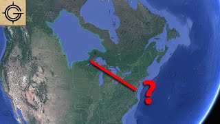
You can see where that body of water was on Google earth in Canada.
You can also see clear water damaged earth south of Canada on the west coasts of North and South America. The water damage reached as far east as western Texas.
This also could have been referring to Lake Corcoran, may not have been salt water but a giant lake that filled the entire San Joaquin Valley. Central California could have been what the Natives were talking about. Before it drained out and dried up it would have seemed like a big inland sea.
The fact that they had two inlets from the ocean near the straight of Juan de Fuca and the Columbia river is impressive/interestingly lucky
For sure they were talking about Salt Lake. even from a plane it looks like an ocean, so I'd imagine a few fellas on horseback saw it and tasted the saline water and deduced they found a sea. It was also probably a LOT larger back then, just in the ~35 years since my mom visited when she was a teenager and when I first visited 3 years ago the water level was significantly lower. They probably landed on its shore, explored a few miles and then extrapolated from what they could see with a sight glass and compared it with native accounts (which may have been handed down generationally from the historic lake missoula) and combined historical lore with what was present day fact and said uh yeah guys theres the sea
So living in eastern Oregon and gathering lots of local history; there used to be very large Ody of water that covered a vast area in eastern Oregon. It was recorded by trappers and settlers in the 16th, 17th, 18th and 19th centuries. It has long since dried up.
Is most likely the great Lahonton sea, which covered much of Nevada on up into southern Idaho. Is still here, just dried up. Evidence is all around if you drive around Walker lake near Hawthorn and observe the horizontal water lines around the lake (receding) and see how far up the mountains they go.
I live in Lesser Slave Lake Alberta. Some of our older history says the lake/sea was very large. I believe after the latest ice age there were enormous shallow lakes that swallowed up the prairies until the waters drained to the oceans.
Most of the area here is comprised of swampy/boggy land and large sand hills that were previously lake bottom.