Exploring the Power of Flood Simulation in ArcGIS Pro 3.3.3!

ฝัง
- เผยแพร่เมื่อ 9 ก.ย. 2024
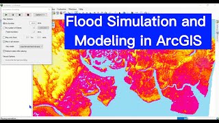
- Excited to delve into the latest capabilities of flood simulation using ArcGIS Pro 3.3.3! This powerful tool leverages shallow water equations to model water movement and accumulation within a defined area of interest. By creating one or more flood simulation layers in a scene, we can run various scenarios and visually analyze the outcomes. Whether it's increasing rainfall or obstructing a waterway, the flexibility to adjust scenarios allows us to understand the impacts and make informed decisions.
pro.arcgis.com...


![[UNCUT] The Loyal Pin ปิ่นภักดิ์ EP.6 (2/4)](http://i.ytimg.com/vi/GgeGQOP10RQ/mqdefault.jpg)


How can I convert the result to a feature layer with time, in order to use this simulation with a time slider in the ArcGIS API 4? Can you create a video tutorial for this?
you can export the raster layers based on the timestamp using "export analysis result" tool in the simulation tab, then convert those multiple rasters into netcdf file. Finally, you can visualize that with time slider