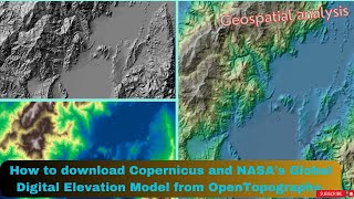
Download digital elevation model with spatial resolution 10m

ฝัง
- เผยแพร่เมื่อ 6 ต.ค. 2024
- ALL LINKS : bit.ly/2XCQ33k
###### SUBSCRIBE AND SHARE ######
WEB Site : www.learngeom.com
FACEBOOK Page : / elbouhali.geo
TH-cam Channel : / learngeomatics
digital elevation model 10m, dem 10m, download dem 10m, download digital elevation model, Download digital elevation model with spatial resolution 10m, Download dem with spatial resolution 10m, mnt 10m, télécharger mnt 10m, modèle numérique de terrain 10m, mnt image radar, dem radar image, dem snap, mnt snap, dem sentinel1, digital elevation model, dem, gis, digital elevation model10 m, dem arcgis, dem snap 10m.
Downloading Digital Elevation Data
Downloading Digital Elevation Model (DEM) for free
digital elevation model 10m
digital elevation model
Download High Resolution DEM data Free
How to Download Free Digital Elevation Model
DEM Generation using Sentinel-1 images in SNAP
DEM Generation using Sentinel-1
DEM Generation in SNAP
dem generation in SNAP
dem generation from sentinel-1
dem extract from sentinel-1
DEM Creation from Sentinel 1 Imagery using SNAP
creating DEM with Sentinel-1 in SNAP


This is not a sentinel processed DEM. As u selected the Digital elevation model option as "sentinel 3sec" and output as "DEM" in the Terrain correction table, it processed the srtm 3sec dem as a output. This is just an SRTM DEM.
That is not the procedure, to generate a DEM you need two SLC images. That DEM that you download is from the SRTM that is used to correct the terrain.
Thank you
@@elbouhaliabdelaziz Hi can I get you contact Email. I am from Indian Institute of Technology, Dhanbad
It is not 10 m resolution DEM. It is 30 m resolution DEM re sampled to 10 m. You are changing only pixel size of the source data
Thanks alot it works, just that one can not import two layers from the plugin at once
Thanks for sharing. I do the test following the video. But, the resultant DEM has a resolution of about 50 m. The hillshaded image is also blurrier than the 30 m SRTM data. What am I missing in the processing?
thanks a lot!
Ramadan mubarak
Does this mean that if one need DEM let's say for the entire southern Africa they will have to download each scene covering the area and then subset it after?
Like there is no way to download it at once?
You can download scene by scene
It better using SLC or GRD? In another source they using 2 images sentinel-1 and using unwrapping process to change phase to elevation
Why generated model has much different max-min values than original?
Thank you, I will try to understand the problem
That is not the procedure, to generate a DEM you need two SLC images. That DEM that you download is from the SRTM that is used to correct the terrain.
I applied all the steps and got the file with a resolution of 10 meters as I explained in the form, but when I want to apply some operations to it, such as extracting the water network and river basins, this process is not completed and a number of errors appear. Is there a solution, thanks.
The altitude is not the same in two examples.
Thank you, I will try to understand the problem
when you try to check DEM data, it actually say above it will autodownload The Shuttle Radar Topography Mission (SRTM) 3-arc second data, which has a spatial resolution of approximately 90 meters. are you sure this is 10m resolution or is it just the 2d imagery?
also, you have the option to change it to SRTM 1 arc which give you 30m accuray for free. please advise if you really are improving these 30m elevation data using satalite imagery or is it just an overlay like every other open source elevation map. I am new to this GIS stuff
Can I ask you something sir? what arc second is 10 meter resolution?
Thank you and Godbless.
And is it better to use than 30 meter dem resolution?
Thank you from Nepal!!
You are welcome
when i add the 12.5 file to arc map it is imported correctly,, however i cant do fill and fill direction on it.. i can do hill shade or other function but the fill is not working keep giving me error... do you know why??
ANY THING FOR GENERATING DTM TERRAIN MODEL
What is the reason for not being able to resume the download process from this site
I need a 10m resolution download for the whole of Africa. Is that achievable easily?
It's not easy
Is there a way for me to resume the download of the Sentinel 1
11:34 how is it with two images? Is it possible or better to take one image at a time?
thanks for posting
You can take one by one,
Great! Thank you for sharing!
Thank too
What should be the specification of Pc for smooth processing...
I5 and RAM 8G is good
@@elbouhaliabdelaziz what about for amd processors?
Great, thank you a lot for your video.
Welcome!
having trouble in arcGIS pro
thankyou!
Thanks, well done.
Thanks
can you give us alink to the site ?
www.learngeom.com/2021/10/create-mnt-dem.html
gracias por el contenido
Gracias
Excelente video….
doese this form cover the republic of yemen
Yes all the world
GOOD
Hi why the window appearing black ??
Hay idioma Español
Bienvenido
Pendiente