
ฝัง
- เผยแพร่เมื่อ 5 ต.ค. 2024
- Accompanying video for our RSS 2018 publication titled "SegMap: 3D Segment Mapping using Data-Driven Descriptors": arxiv.org/pdf/...
The approach will be available open source with easy-to-run demonstrations at github.com/eth...
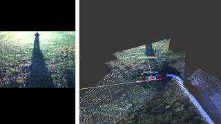
Abstract- When performing localization and mapping, working at the level of structure can be advantageous in terms of robustness to environmental changes and differences in illumination. This paper presents SegMap: a map representation solution to the localization and mapping problem based on the extraction of segments in 3D point clouds. In addition to facilitating the computationally intensive task of processing 3D point clouds, working at the level of segments addresses the data compression requirements of real-time single- and multi-robot systems. While current methods extract descriptors for the single task of localization, SegMap leverages a data-driven descriptor in order to extract meaningful features that can also be used for reconstructing a dense 3D map of the environment and for extracting semantic information. This is particularly interesting for navigation tasks and for providing visual feedback to end-users such as robot operators, for example in search and rescue scenarios. These capabilities are demonstrated in multiple urban driving and search and rescue experiments. Our method leads to an increase of area under the ROC curve of 28.3% over current state of the art using eigenvalue based features. We also obtain very similar reconstruction capabilities to a model specifically trained for this task.
Contact: renaudube(at)gmail.com, andrei.cramariuc(at)gmail.com and dugasd(at)ethz.ch
Related videos: www.youtube.co.... and www.youtube.co....


This is really neat!
Creating segments be beneficial for many applications!
Sir can u plz tell me how can we represent the carriage width, formation width, and total width of a road by using the segment mapping method?
What resolution can you get with this kind method/program? Is it something in the cm range?
We do not have ground truth data to evaluate the accuracy of the point cloud. In this demonstration, the localization transformations are estimated based on the segment centroids. Regarding the accuracy of these transformation, we can say that registering the point clouds of the corresponding places using ICP results in a refinement of the localization transformation by, in average, 15cm. I hope that helps!
Studio "Archimed Production" is looking for manufacturers of robots, drones, unmanned vehicles and buses, unmanned aerial vehicles, aircraft manufacturers and helicopters , unmanned marine vessels, unmanned power stations, for mutually beneficial cooperation in the science fiction film about artificial intelligence .
Paper: arxiv.org/abs/1804.09557