Become a 2D Flood Modelling Pro in Just 1-Hour | Step-by-Step Tutorial with HEC-RAS 6.5

ฝัง
- เผยแพร่เมื่อ 20 มิ.ย. 2024
- Welcome to our comprehensive tutorial on 2D flood modeling using HEC-RAS 6.5! In this video, we dive deep into the sophisticated of river engineering, focusing on how to accurately simulate flood events. Whether you're a student, a professional in the field of hydrology, or simply a curious mind, this video is crafted to enhance your understanding and skills.
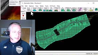
We begin by introducing the basics of Digital Elevation Models (DEM) using SRTM data, a crucial component in terrain mapping for flood modeling. From there, we'll guide you through the intricate process of mesh generation, unsteady flow dataset, and the importance of the courant number in numerical modeling to ensure stability and accuracy.
Detailed step-by-step instructions will demonstrate how to set up your project in HEC-RAS 6.5, followed by running simulations to predict flood depth, velocity, and extent. You'll learn how to interpret these results to make informed decisions in flood risk management.
Throughout the video, we'll provide practical tips and insights to help you master the software and the theoretical concepts. Whether you're looking to protect a local community from flood hazards or conducting academic research, this video will equip you with the necessary tools and knowledge.
Don't forget to engage with us in the comments, share your experiences, and subscribe for more insightful content like this. Happy modeling!
#floodmodeling, #hecras, #riverengineering, #digitalterrainmodel, #srtm, #numericalmodeling, #meshgeneration, #courantnumber, #flooddepth, #floodvelocity, #floodriskmanagement, #civilengineering, #environmentalengineering, #waterresources, #hydraulicmodelling, #hecrastraining, #floodsimulation, #floodprediction, #floodprevention, #floodextent


Thanks for sharing
you're welcome
another great tutorial, if you can please do hec hms
Thank you so much. Yes, of course. As soon as possible I'll record this course about HMS
thank you
You're welcome
You forgot to discuss equations like Diffuse wave and SWE
you got +1 subscriber! Thnx
Thanks for your feedback
Why the water surface elevation in the profile lines is not horizontal? Inclined at the banks and also WS line not properly connected. What are the reasons and how to rectify this error?
That's a good question, but keep in your mind that this models is a 2d, not 1d model. In 1d models the water surface is horizontal but it's not true for 2d models and due to the flows coming from both sides to the main channel the water surface is not horizontal.
Sir, can you please do 1D unsteady flow analysis
Yes, Of course, I'll record this tutorial as soon as possible
Follow my channel to get informed about the latest videos
Hello sir, is it necessary to use ArcMap, or can we use any alternative software?
You can use every GIS-based software such as QGIS, SagaGIS or Map-Widow GIS
Why don't you use other DEM data, e.g. NASADEM, Copernicus DEM?
As I mentioned in the video, You can use different DEM sources and in this tutorial, I selected SRTM30m DEM. However, based on my experience, SRTM and ALOS outperform other DEMs. I recommend you to test different DEMs using ground survey topographic maps to find the best one for your case study.
@@HydroAI2024 Thank you for your reply, based on my current research findings, Copernicus Dem performs well in some areas, it may be the reason for DSM, thanks again for the video
@@mingjianwu4277 Thanks for sharing information and knowledge. I will try my best to test this DEM in my further studies.