HecRas 1D flow modeling for beginners: Projection file, steady flow, bridge, flood zone

ฝัง
- เผยแพร่เมื่อ 18 ต.ค. 2024
- HecRas 6.3.1 for beginners
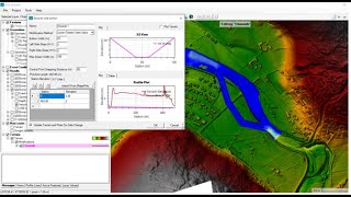
Here you can find a general explanation of HecRas 1D modeling of flow.
I talked about how to find the projection file, how to find the river centerline, DEM file and Rasmapper, adding a bridge, evaluating the results, flood zone and etc.
If you have an accurate DEM file then you don't need to add cross sections from the excel file.
(NTNU numerical modeling and hydraulic course- 2023)


![일상 속 기분 좋음 [Proto disco meme]](http://i.ytimg.com/vi/DwmEIaZ7XGQ/mqdefault.jpg)


بسیار عالی.
thank you how do obtain discharge value? river length, slope ?
This is so simple, just use Rasmapper. I explain it in other videos or this video somewhere. Good luck.
thank you for your response, my data is directly imported from ArcGIS. I am not hydrologist, get some problem to fully understand the issues just I am doing steady flow analysis for research purpose.
Very informative and vaulable content. Could you share data used for 1-D and 2-D flow analysis?
Thanks. I should get permission to be sure about it. I suggest using another set of data, which you can find in the net.😊
Hi Sir, very educative. Could you kindly help me understand why you didn't need the flow path ?
Could you please explain more about your question?
Manning from 0.03 to 0.3 ! In the calibration.
Could you please explain more your question? I will be happy to help and answer it. Thanks.
Moreover, If you listen and follow the video carefully, you understand the steps and the fact that this video is prepared just for education purpose in the class. It is not a real project and values.
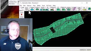
how did you get the cross sections details, form terrain model or the cvs file imported in the beginning? no clarity on this, please explain.
I think it is clearly explained that you can have the excel file from field and survey. Generally you have 2 options to have cross sections, one from survey or field and second make them in hecras or gis with geodata. I used both options in the video for learning purpose…
Good luck
If we import cross sections and rivers bank lines directly from shape file without drawing them manually. Will this be correct or it will influence the simulation
If I understand your question correctly, and as I said in the video, your answer is:
Yes, it would be correct if your DEM file has a high accuracy.
I show it this way in the video due to the assignment and learning part of the modeling.😊
Sir, I'm not getting any data in the station and elevation cross section table. After plotting the cross sections, I'm only getting the data in D/S reach lengths and main channel bank station. If you could please provide the answer, it would be really helpful.
try again
Can you please prepare model for canal
just learn the steps from this video and repeat it for your model
@@behnambalouchi Thank you
can you share the data so that we can follow up please
thanks
I am not sure if I can share them, so I suggest to find a data yourself and just follow the steps. There is no need for excel file, you just need a DEM file and assume other parameters.