
- 97
- 31 407
Andy Schlichting
เข้าร่วมเมื่อ 30 มี.ค. 2021
Climbing Aconcagua, the highest mountain in the Western Hemisphere
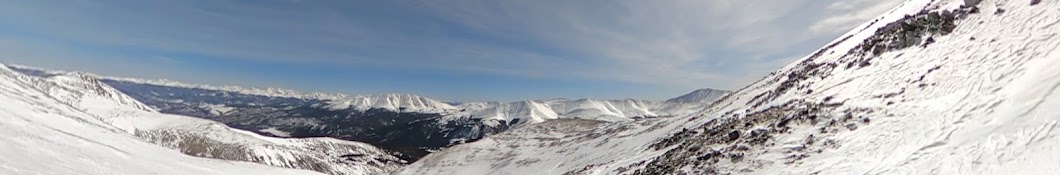
Aconcagua (6962 meters, 22,841 feet) is the highest mountain in the Western Hemisphere and highest mountain outside of Asia, located in Argentina near the border with Chile between Mendoza and Santiago.
My sister and I climbed this the first week of January 2025. We arrived already acclimatized from Ecuador so we did an accelerated ascent, joining a group at base camp that had been on the mountain for several days already.
We spent our first night in Confluencia before heading to base camp at Plaza de Mulas. The acclimatizing schedule is fairly gentle on this mountain gaining roughly 500 meters between each camp.
There's a lot to share about this mountain--too much to fit in here, but hopefully the day-by-day video recap tells the story well.
I ended up coming just short of the summit, 250 meters to be exact, after getting severely dehydrated due to Diamox that the doctors and guides told me I needed to take (it's a long story!). When I return to this mountain (or any other mountain for that matter), I will definitely not be using Diamox and I do not recommend it unless you have a medical reason to take it.
We used Gente de Montanha for guides.
มุมมอง: 1 905
วีดีโอ


Climbing Volcán Chimborazo, the highest mountain in Ecuador
มุมมอง 65วันที่ผ่านมา
Chimborazo is a well-known volcano around the world both for being the highest point in Ecuador and for being the place on earth closest to the sun. If you're wondering how can a 6,267-meter (20,561 feet) mountain be closer to the sun than Mount Everest and other 8,000-meter peaks in the Himalayas, it is because of Chimborazo's proximity to the equator and location in earth's equatorial bulge, ...

Climbing Volcán Cotopaxi in Ecuador, one of the world's highest volcanoes
มุมมอง 208วันที่ผ่านมา
Volcán Cotopaxi is one of the most iconic volcanoes in the world with its majestic height and symmetrical cone shape, inspiring an apparel brand and attracting hikers and climbers from all over. Standing at 5,897 meters (19,347 feet) above sea level, it is the second-highest mountain in Ecuador, and it's located about two hours south of the capital city of Quito. The biggest challenge on the mo...

Hiking Rucu Pichincha in Quito, Ecuador
มุมมอง 1814 วันที่ผ่านมา
We hiked Rucu Pichincha on Christmas Day 2025 to prepare for Cotopaxi, which we summited two days later. Rucu Pichincha (4,696 meters/15,406 feet) is part of an active volcano in Ecuador's capital city of Quito. Rucu is the second-highest peak and the shortest hike of the several summits. The tallest peak, Guagua, is about 100 meters higher than Rucu. Rucu is a relatively easy hike after taking...

Hiking Cerro Corazón near Quito in Ecuador
มุมมอง 1914 วันที่ผ่านมา
Cerro Corazón is a great acclimatizing day hike for some of the bigger volcanoes in Ecuador. We did this on Christmas Eve 2024 and it's just a short drive from Quito, located inside the Ilinizas ecological reserve and near Cotopaxi. The beginning of the hike starts from a ranch with alpacas and initially goes up a closed road for almost two kilometers before reaching the trailhead. From there, ...

Climbing Volcán Antisana in Ecuador
มุมมอง 9914 วันที่ผ่านมา
Volcán Antisana is one of the wildest mountains I have ever climbed. Located about two hours outside of the capital city of Quito in Ecuador, it's an easy two-day, one-night trek. The large dormant volcano reaches an altitude of 5,758 meters (18,891 feet). It is definitely the most beautiful mountain I have climbed, full of dramatic crevasses and seracs, though those add to the danger. Most the...

Climbing Volcán Iliniza Sur in Ecuador
มุมมอง 1821 วันที่ผ่านมา
We climbed Volcán Iliniza Sur in Ecuador in late December 2024. It is the higher and more technical summit of two twin peaks called the Ilinizas, located in Reserva Ecológica Los Ilinizas, a little more than an hour south of the capital city of Quito. The easy hike up to the refuge takes a little over two hours and puts at you 4,700 meters above sea level, or at over 15,400 feet. From the refug...

Hiking and Skiing Dyer Mountain near Leadville, Colorado
มุมมอง 114หลายเดือนก่อน
We picked a beautiful, but windy mid-December day to attempt Dyer Mountain, one of Colorado's 100 highest peaks. Located just outside of Leadville above Iowa Gulch and adjacent to the more-famous 14er Mount Sherman, Dyer Mountain stands at 13,861 feet above sea level. During the summer, hikers can drive to above 12,000 feet on a rough road, but the winter closure adds 3.4 miles each way and a l...

Adaptive Skiing in Mayflower Gulch with The Lockwood Foundation
มุมมอง 52หลายเดือนก่อน
The Lockwood Foundation debuted its Dynamique Biski on Dec. 14, 2024, with adaptive athlete Tom Pham at Mayflower Gulch near Leadville, Colorado. The new equipment will now allow adaptive downhill skiing with the organization with the assistance of volunteers. For more information, visit www.thelockwoodfoundation.org.
Hiking Colorado's Mount Bierstadt in Winter Conditions
มุมมอง 982 หลายเดือนก่อน
Mount Bierstadt is one of Colorado's 58 famed 14,000-foot peaks, standing at 14,066 feet above sea level. Located in the Front Range only an hour from Denver near Georgetown, it is one of the most popular 14ers in the state. It is a simple out-and-back hike from the trailhead at the top of Guanella Pass and a gentle ascent. The only challenging part of the hike is the final 300 vertical feet wh...
Hiking Mount Sniktau on Loveland Pass in Colorado
มุมมอง 702 หลายเดือนก่อน
Mount Sniktau is one of the easiest ways to get over 13,000 feet in elevation from Denver in Colorado's Front Range mountains. Located off Loveland Pass near the Eisenhower/Johnson Tunnels off I-70, Mount Sniktau (13,239) is normally a very easy hike, about four miles round trip from the parking area at the top of the pass. We did this hike on Thanksgiving Day 2024 and it was just one day after...
Hiking Argentine Peak and Mount Wilcox in Colorado's Arapaho National Forest
มุมมอง 552 หลายเดือนก่อน
We hiked two 13ers off Guanella Pass in Colorado's Arapaho National Forest in mid-November 2024. Argentine Peak (13,743 feet) and Mount Wilcox (13,414 feet) can be done in a loop, either with or without nearby Square Top Mountain. We chose to just do the two as this was still nearly a 10-mile day in snow. The hike begins at the Silver Dollar Lake trailhead and over two-miles in, we reached Silv...
Hiking Rocky Mountain National Park's Lakes
มุมมอง 272 หลายเดือนก่อน
I hiked all of the lakes in the four valleys accessible from the Bear Lake Trailhead in Rocky Mountain National Park in early November 2024. It was a great time of year to hike because crowds are smaller and the timed-entry system that is in place over the summer ended in October. Though the trails were icy and snowy, that was mitigated by wearing microspikes/traction. On this day I hiked to Be...
Hiking to Geneva Lake in Colorado's Maroon Bells-Snowmass Wilderness
มุมมอง 393 หลายเดือนก่อน
Geneva Lake is located near the town of Marble, Colorado, in the Maroon Bells-Snowmass Wilderness. This aqua-green-colored lake sits at the base of Snowmass Mountain, one of Colorado's famed 14,000-foot peaks, and Hagerman Peak, one of Colorado's highest 100 peaks. The seven-mile drive to the Lead King Basin Trailhead is quite rough from the town of Marble and requires a high-clearance 4WD vehi...
Climbing Hagerman Peak near Aspen, Colorado
มุมมอง 243 หลายเดือนก่อน
Hagerman Peak is one of Colorado's 100 highest peaks at 13,848 feet above sea level and is located near Aspen in the Maroon Bells-Snowmass Wilderness. To reach the Lead King Basin Trailhead for this route, however, you approach from the town of Marble, on the opposite side of the mountain range from Aspen. For me, this was one of the prettiest hikes I've done because I reached the summit minute...
Climbing Capitol Peak Near Aspen, Colorado
มุมมอง 1653 หลายเดือนก่อน
Climbing Capitol Peak Near Aspen, Colorado
Hiking to Capitol Lake near Aspen, Colorado in the Maroon Bells-Snowmass Wilderness
มุมมอง 343 หลายเดือนก่อน
Hiking to Capitol Lake near Aspen, Colorado in the Maroon Bells-Snowmass Wilderness
Hiking French Mountain and Casco Peak in Colorado
มุมมอง 284 หลายเดือนก่อน
Hiking French Mountain and Casco Peak in Colorado
Hiking Grizzly Peak and Garfield Peak near Twin Lakes, Colorado
มุมมอง 304 หลายเดือนก่อน
Hiking Grizzly Peak and Garfield Peak near Twin Lakes, Colorado
Climbing the Southwest Ridge of Mount Sneffels in Colorado
มุมมอง 1644 หลายเดือนก่อน
Climbing the Southwest Ridge of Mount Sneffels in Colorado
Hiking to Blue Lakes in Colorado's San Juan Mountains
มุมมอง 684 หลายเดือนก่อน
Hiking to Blue Lakes in Colorado's San Juan Mountains
Climbing Wilson Peak and Gladstone Peak in Colorado's San Juan Mountains
มุมมอง 384 หลายเดือนก่อน
Climbing Wilson Peak and Gladstone Peak in Colorado's San Juan Mountains
Climbing Colorado 14ers El Diente Peak, Pin Point, Mount Wilson, and South Wilson
มุมมอง 614 หลายเดือนก่อน
Climbing Colorado 14ers El Diente Peak, Pin Point, Mount Wilson, and South Wilson
Hiking to Navajo Lake in Colorado's San Juan Mountains
มุมมอง 354 หลายเดือนก่อน
Hiking to Navajo Lake in Colorado's San Juan Mountains
Hiking California Peak, Mount Lindsey, Iron Nipple, and Huerfano Peak in Southern Colorado
มุมมอง 524 หลายเดือนก่อน
Hiking California Peak, Mount Lindsey, Iron Nipple, and Huerfano Peak in Southern Colorado
Adaptive Athlete Summits Mount Elbert, Colorado's Highest Mountain with The Lockwood Foundation
มุมมอง 6424 หลายเดือนก่อน
Adaptive Athlete Summits Mount Elbert, Colorado's Highest Mountain with The Lockwood Foundation
The Lockwood Foundation summits Pikes Peak via the Barr Trail
มุมมอง 5155 หลายเดือนก่อน
The Lockwood Foundation summits Pikes Peak via the Barr Trail
Hiking Mount Oklahoma in Colorado's Mount Massive Wilderness
มุมมอง 315 หลายเดือนก่อน
Hiking Mount Oklahoma in Colorado's Mount Massive Wilderness
Hiking Mount Ouray in Colorado's Sawatch mountain range
มุมมอง 275 หลายเดือนก่อน
Hiking Mount Ouray in Colorado's Sawatch mountain range
Climbing the Crestones Traverse between Peak and Needle via Cottonwood Creek
มุมมอง 905 หลายเดือนก่อน
Climbing the Crestones Traverse between Peak and Needle via Cottonwood Creek
Thanks for sharing and congratulations. If all goes well begin of 2027
on a scale of 1-10 how difficult do u think it was to summit?
It's very easy from a technical standpoint--it's a simple walk/hike from Horcones to the summit. However the altitude is the challenge, but I felt pretty acclimatized after coming from Ecuador before Aconcagua. Many people struggle even at base camp (over 14,000 feet) if they're coming from sea level. I'd give it a 5 or 6 out of 10 because the altitude is a real challenge, but that's really the only challenge on this route.
Your video is truly beautiful and inspiring. As a fellow creator, I appreciate your work. Love connecting with other creators!. 👍2
Your video is truly beautiful and inspiring. As a fellow creator, I appreciate your work. Love connecting with other creators!. sub & 👍20
Congrats! So beautiful!
Hi, I'm Domingo, a resident of Nairobi. I want to climb Batain Peak on Christmas days or January next year. we can hike together during that time. we can share the guide fee BTW. if you are in Nairobi, we can have a meet and training together. looking forward to hearing from you
Nice souvenir,
Hi. I'm preparing myself to do this. Any way you can get me in touch with Josephat or John? Thanks!
Sorry I missed this (I was in South America two weeks ago). I have John's WhatsApp I could send you privately. Otherwise, I recommend contacting Go To Mount Kenya--that was the company I used and they worked for. Highly recommended.
There is nothing "little" about this mountain.... insane...
Nice video. I am doing this next year. Hope we get to summit. Thanks for posting!
Wow, brilliant episode my friend! Area looks amazing!
To be up there with no wind must’ve been amazing. Congrats on a safe traverse.
Thanks! It was a dream day
Ruach ha-kodesh
Nice view from a beautiful mountain that seems to be overlooked by Snowmass next to it.
You finally reach the top and realize you have to go down that same way.
When I was on the catwalk I didn’t even think I was on it until I saw the same rock from your video. It’s not half as narrow as this fish eye BS makes it out to be.
The wide angle exaggerates the exposure a slight bit, but this traverse is not for the faint of heart. I don't think I could pull it off. Hats off to the climber.
would love to hit this up next year if you're down for round 2
I'll absolutely return to this one!
Assuming you started at Rock of Ages Trailhead...how is the dirt road to trailhead? Passenger or 4x4?
We actually did Navajo Basin so I can't speak to ROA unfortunately. We did El Diente-MW the day before.
It's absolutely beautiful up there. Missing it from TN right now!
Looks like a great place for a Par Coeur competition.
😂
Good climbing with ya Andy! Glad to have that one in the rearview.
Likewise! Hope to see you again soon
what shoes?
I believe I was wearing Lowa mountaineering boots on this
So happy for you Tom! I love you like a brother. I’m glad this was made possible from the Lockwood Foundation ❤
I like you testing out the stability of a rock with the old palm tap method at 1:30.
Congratulations, way to go Tom! Thanks to the Lockwood Foundation and all the volunteers for making it accessible!
I have AMN, as well. I love this video. I am also engaged in adaptive sports and recreation - wheelchair basketball and handcycling.
If you are in Colorado, we'd love for you to join The Lockwood Foundation for a hike!
Love the video. Well done Andy!
@@andyschlichtingI’m afraid that I am in Washington state, or otherwise, I would totally take you up on that! I love what your organization is doing for adaptive sports and recreation. This puts a big smile on my face.
I also climbed the Citlaltépetl (Pico de Orizaba) for the first time on december, I am mexican, and i love our mountains, this ine was the hardest to me, Iztaccihuatl the second. Congrats for the summit
Congrats to you too!
FABULOUS! What an awesome achievement! Blessings to ALL who made this possible!
This is absolutely incredible!!! Congratulations man!!
Hey! Thanks man! It was a fun trip with a ton of wonderful people!
Staking your life on the assumption that those loose-looking rocks are in fact rock solid. Jumping and grabbing onto holds that you have no idea of their solidity. I mean, really dude? Hey, I've got a great climb for you, one of the Willis Wall routes on Mt. Rainier 🤣😂🤣😂
Wow. Very inspirational! I am always thankful for being able to hike around. I know not everybody can. Great job to everyone involved.
literal f'ing insanity
I’ll pass
‘That route OSHA certified?
😂
epic!!!
Yeah, don't bang on that stuff too hard -- Ellingwood to Blanca is no picnic, either
Nice video, shame about the audio.
My best friend did this traverse probably 15-20 years ago. He said it was the sketchiest thing he’s ever done. Congrats! 😅
Can't fix stupid
That doesn't seem stable homie
Looks like is more dangerous than Capitol peak .
Oh yeah. Capitol is a breeze after this!
Geez, and I thought Capitol Peak knife ridge was bad!
Capitol was a breeze after this :)
@@andyschlichting Haha you're a better man than I! I wasn't even aware that this was a thing. Watching the video, the wet palm index was almost as high as when watching the video of the free climb of El Capitan. In your opinion, what is the most difficult Colorado 14er? Just curious, I don't do them much anymore due to crowding. And the weather pattern seems to have shifted in the last decade, storms started coming in much earlier in the day. All the best to you and yours!
Much respect, because I'm on my couch watching from my phone, palms are sweaty already and I think I just let loose some digested food in my pants 😂
😂😂😂
Amazing views and outstanding weather! If I woke up in this place, I think that I would walk a little bit slower!
Oh dear lord 😂😂😂😂
I'll stick to driving across Trail Ridge Road.
Wow, amazing vid
Where is the rolling meadow with wildflowers and cool stream?
Down below the peaks :)
Bro this was risky but you made it to the top😮 can't wait to see you climb k2