
- 5
- 193 117
Jon Cooper
เข้าร่วมเมื่อ 26 ส.ค. 2012
How to improve the speed an ease of urban character analysis and coding - Welcome to ViewCue 4.0
How to improve the speed an ease of urban character analysis and coding - Welcome to ViewCue 4.0
มุมมอง: 442
วีดีโอ


ViewCue - enhancing places, improving lives.
มุมมอง 4946 ปีที่แล้ว
ViewCue challenges the status quo, it will change the way you think about the design of place. Dr Jon Cooper talks about the new concept of visual texture - a revolutionary new approach to design.

CityCad plan import
มุมมอง 2.9K8 ปีที่แล้ว
A short description of how to upload an OS base plan image into CityCad as a ground plane image.

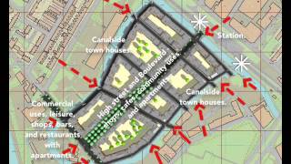
Urban Design Techniques. Part 1. Creating a basic urban design structure.
มุมมอง 189K8 ปีที่แล้ว
This video is for those who want to learn the basic methods of creating an urban design layout and supplements lectures given on urban design modules at Oxford Brookes University, UK, by Dr Jon Cooper.
Was the second part ever made?
What is collaboration thinking ? What is a collaborative approach ? Why is collaborative mindset important ? What is another word for collaborative ?😂😂😂😂😂😂😂😂😂😂😂
Perfect❤ it's the best explanation
Hi what is programme you are using?
Been saving lifes since 2016, thank you sir
Which websites can I use to create neighborhood planning
Please send the software name and link. So helpful it.
This neighborhood already looks breathtaking. It's interesting how simple buildings, with similar heights, carved out windows (instead of curtain walls), good color combinations, and well defined ground floors, etc., in combination with street trees, can create beautiful cities. If you look at the most beautiful cities on the planet, such as Stockholm, Copenhagen, Helsinki, St. Petersburg, etc., they all have followed these rules. We don't need 'starchitects' to make beautiful cities, what we need is good urban planning and design.
hello sir, would you tell me the name of this software please
Which is this please
was really helpful. Thanks a lot.
Why run roadways across the limited amount of green space?
How do we determine the dimensions of the width of the road that we will use in each of the grids? Sorry, I'm still just learning Urban Planning in semester 5, architectural engineering
The design process is not left up to a single planner but a team of specialists who ideally work together to create a system that works best for the use case. For the purpose of deciding on road dimensions it's going to be the transport engineer attempting to create the most efficient system within the teams vision. Furthermore, sometimes things like road width is constrained to city, state, or federal building codes depending on where it's being constructed.
Hello guys recommend Godwin Abogonye, for urban and regional planning videos, check out this channel " urban and regional planning in Nigeria "
What is the software name
Jon I showed today you video to my students! thanks
very well executed and told
Unbelievable... Beautiful.
Worth a whole semester of urban design course at Arch Deptmnt in 6min, Thanks Dr. Cooper
This is bullshit
You ended up using Bath as a test case!
thank you so much
woah, haven't seen this before
very helpful thanks and congrats
Thnx
Is City Cad Academic version still available? I’d love to use it like this.
impressive
❤️✌️
Hi Everyone, Thanks for the various comments on the UD video and apologies for not responding to questions sooner. The software used to make the model is CityCad by Holistic City Ltd. They have just released major upgrade. Follow this link to access the software. www.holisticcity.co.uk/services/citycad/ They have a free to use academic version.
Thnks
Thanks dr
This is very helpful, what software is this ?
Anybody else here so they can improve their cities on Skylines?
LOL
Welp, now we know.
what is the name of the software program in presentation ?
CityCAD
Ive been there in Ladywood. Lots of waterfront properties being built now with London money for mainly middle class people in Birmingham. It was formerly an industrial manufacturing site before they closed down by 1990's.
YOU ARE NICE
this is very helpful.
1:35 talks about red and blue routes and then it draws red, orange, blue and yellow routes, what are the orange and yellow routes for? 🤷🏼♂️
looks like a transition between red and blue ones
I think yellow for municipal facilities,orange for risk
Can i know what software is it?
what software your using
The drawings look like plastic and the trees are out of scale.
What is the name of software ?
Azam Barjasteh Houdini with python code
Great presentation 👍🏻
Thanks
Thank you for sharing this! Good bye beautiful green space! We will miss you :)
This is so interesting. Shame there isn't more information regarding urban planning on TH-cam.
planning and design is more subjective and dynamic form place to place its enough to consider some principles in ur design
@Feynstein 100 the channel Not Just Bikes gives some casual insights in urban planning and its effects on how pleasant a street/district can be thanks to good planning
@@photoo848 Oh okay. Thanks for the recommendation 🙂
My how things change ;)
@@TAP7a They do? 🤔
Hello, could u please provide a link for downloading it?
where I can find a guide about this software? I want to start from the basic..like where did you find the photo ,that you use as a background?
It was a city in China I did a site study on
Very cool software. Check out this innovative pocket park in the middle of Chicago's historic gallery district, focused on providing green space for it's residents. th-cam.com/video/qY7uWRdWPhg/w-d-xo.html
How totally frightening, particularly that this comes out of a university and one of its professors
Its really teeth grinding when gray hairs start imitating teens. Does the written video description even make sense
Explain?
sarcasm?
I’m not a professor, this was a project I did in my studies
Very helpful! Basic steps to creating a solid land community master plan. Thank you.