
- 144
- 50 496
GIS Schools
Pakistan
เข้าร่วมเมื่อ 15 ต.ค. 2023
Welcome to GIS Schools, your go-to destination for cutting-edge Geographic Information Systems (GIS) knowledge and tutorials. Suppose you're passionate about harnessing the power of GIS technology to create advanced web applications, conduct mobile surveys, or explore the world of GIS libraries and languages. In that case, you've come to the right place!
🖥️ Advanced GIS Web & Mobile Development: Dive into the realm of advanced GIS web development, where we'll guide you through the latest techniques, best practices, and tools to build powerful and interactive web applications that leverage geospatial data.
🌐 Exploring GIS Libraries and Languages: Discover the multitude of GIS libraries, APIs, and programming languages at your disposal. We'll walk you through their features and how to use them effectively to create dynamic GIS solutions.
📊 GIS Data Visualization: Uncover the art of GIS data visualization.
Exploring the HTML Tags | HTML and CSS for Beginners Complete Project | Part 2
SourceCode: gisschools.com/course_details.php?title=Exploring+the+HTML+Tags
In this tutorial, we dive into the basics of HTML by exploring its structure and essential tags. You'll learn how to set up your first HTML document and understand the various components that make up a web page. We cover:
-::- HTML document structure and heading tags.
-::- Using comments and handling white space.
-::- How to create line breaks and use common HTML tags.
-::- Inserting and resizing images within your web page.
-::- Creating hyperlinks to navigate between pages.
-::- Embedding images into links for enhanced navigation.
By the end of this video, you'll be well-equipped with the foundational HTML skills to build a functional web page, and you'll be ready to take on more complex projects in the future.
Don't forget to like, subscribe, and hit the notification bell for more web development tutorials!
00:05:00 - First HTML Code
00:09:05 - Exploring Document
00:17:12 - Headings
00:19:56 - Comments, White Space
00:23:53 - Popular HTML Tags
00:28:34 - Images
00:34:27 - Links
00:38:58 - Clickable Image
00:41:11 - Tables
00:47:08 - Forms
00:54:04 - Lists
----------------------------------
-----------Tags---------------
----------------------------------
#html #css #php #javascript #js #webgis #geojson
------------------------------------------
----------Contact Me:------------
------------------------------------------
Email: sohailgoheer@gmail.com
Website: gisittools.com/
Facebook: web. GISandITTools
Instagram: sohailgoheer
--------------------------
html and CSS tutorial for beginners, best html and CSS tutorial for beginners,
best tutorials to learn html and CSS, learn html and CSS from scratch,
html CSS JavaScript tutorial for beginners, html CSS JavaScript for beginners,
html and CSS beginner tutorial,html CSS tutorial for beginners,learn html and CSS for beginners,
learn html5 and css3 from scratch, html and CSS for beginners,
best tutorial for html and CSS,html and CSS course for beginners, html CSS for beginners
Please Subscribe to my Chanel @GISSchools
มุมมอง: 23
วีดีโอ


What is HTML & CSS? | HTML and CSS for Beginners Complete Project | Part 1 | @GISSchools
มุมมอง 3114 วันที่ผ่านมา
Source Code: gisschools.com/course_details.php?title=What is HTML and CSS? HTML and CSS for Beginners Complete Project Welcome to our new series on HTML and CSS! In this video, we'll start from the basics and guide you through essential concepts in HTML and CSS. This course is designed for complete beginners who want to dive into web development. By the end of this series, you'll not only under...
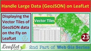
Vector Tiles of GeoJSON data on The leaflet Web Map | Handle The Large data without Map-Server | 23
มุมมอง 8821 วันที่ผ่านมา
SourceCode: gisschools.com/course_details.php?title=Vector Tiles of GeoJSON data on The leaflet Web Map leaflet-geojson-vt: github.com/iamtekson/leaflet-geojson-vt www.gisschools.com Description In today's video, we'll explore how to handle large data GeoJSON files using vector tiles and address the challenges of rendering such files on a map. We’ll walk through the process of managing a 35 MB ...

Geocoding with Leaflet | Search Location by Address or Name on The Map | Leaflet JavaScript | 22
มุมมอง 5821 วันที่ผ่านมา
Source Code: gisschools.com/course_details.php?title=Geocoding with Leaflet - Search Location by Address on The Map In this tutorial, we’ll dive into how to implement Leaflet search functionality to locate specific addresses on a map. We'll be using Leaflet and OpenStreetMap to perform geocoding and display search results with markers. Here’s a breakdown of what we’ll cover: 0:00:20 - Introduct...

Search in a Feature Layer with Input Field in the Leaflet | GIS Data on Web with Leaflet API | 21
มุมมอง 3121 วันที่ผ่านมา
Source Code: gisschools.com/course_details.php?title=Search a Layer Feature in the Leaflet In this tutorial, we will learn how to implement a search functionality in our web application. We will create an input field and a search button to search for objects based on their GID (Geographic Identifier). The video will cover designing the input field and search button, handling errors for incorrec...

How to add Google Satellite imagery as a Base Map in Leaflet | GIS Data on Web with Leaflet API | 20
มุมมอง 6428 วันที่ผ่านมา
Source-code: gisschools.com/course_details.php?title=Google Satellite imagery as a Base Map in the Leaflet In this tutorial, we'll enhance our mapping project by adding a hybrid map layer and a new base map layer. This video covers the transition from using Esri World Imagery to more detailed and widely used imagery. We will also organize our code and improve our map’s functionality. What you'l...

Leaflet Styling for Lines and Polygons | GIS Data on Web with Leaflet API | 19 | @GISSchools
มุมมอง 2828 วันที่ผ่านมา
Source-Code: gisschools.com/course_details.php?title=Leaflet Styling for Lines and Polygons In this tutorial, we dive into styling polygonal lines and other data layers using Leaflet. We focus on enhancing the visual appeal of polygonal data, including boundaries, fields, irrigation lines, and streets. By applying Leaflet's native styling options, we aim to make our maps more attractive and inf...
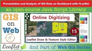
Leaflet Draw & Feature Style Editor : Point, Line, Polygon | Online Digitizing | 15
มุมมอง 100หลายเดือนก่อน
SourceCode: gisschools.com/course_details.php?title=Leaflet Draw Tool - Feature Style Editor - Point, Line, Polygon - Online Digitizing In this video, we continue our web series on presenting and analyzing data on a dashboard using Leaflet. This is our 15th video, and today we will cover the Leaflet Draw Tool, which allows you to create a digitizing tool on an online dashboard. This is a crucia...

Clustering and DeCluttering Markers with Leaflet Plugin | GIS Data on Web with Leaflet API | 18
มุมมอง 48หลายเดือนก่อน
Source-code: gisschools.com/course_details.php?title=Leaflet Clustering - Decluttering Plugin - Marker Clustering Leaflet Cluster Plugin: github.com/Leaflet/Leaflet.markercluster In this video, we dive into the topic of clustering and de-clustering using the Leaflet plugin. Learn how to beautifully present large datasets by effectively managing and visualizing point data. We also cover how to d...
Customize Leaflet Markers with Font Awesome & Point Symbology Plugin | Tutorial 17 | @GISSchools
มุมมอง 71หลายเดือนก่อน
Source-code: gisschools.com/course_details.php?title=Leaflet Marker Point Symbology Style Plugin and Custom Font Awesome Marker In this tutorial, we dive into styling point data using Leaflet. We explore various methods to customize point data appearances, including applying different colors, icons, and shapes based on data types. This video continues from our previous lesson, where we set up v...
The Leaflet: GeoJSON Data and AJAX Plugin | GIS Data on Web with Leaflet.js API | 16 | @GISSchools
มุมมอง 111หลายเดือนก่อน
SourceCode: gisschools.com/course_details.php?title=The Leaflet: GeoJSON Data and AJAX Plugin Leaflet.ajax Link : github.com/calvinmetcalf/leaflet-ajax L.GeoJSON Link: leafletjs.com/index.html#geojson In this video, we dive into exporting shapefiles into JSON format and integrating them into our Leaflet project using AJAX. This tutorial is part of our ongoing series on GIS data presentation and...
LayerGroup And FeatureGroup Control in Leaflet | GIS Data on Web with Leaflet API | 14 @GISSchools
มุมมอง 60หลายเดือนก่อน
SourceCode: gisschools.com/course_details.php?title=LayerGroup And FeatureGroup Control in Leaflet In this video, we continue our series on displaying GIS data on the web, focusing on managing different feature layers in Leaflet. Previously, we created polygonal, point, and line layers. Today, we'll learn how to handle these layers using group layers and feature groups. We explore how to use th...
The Polygon Object | Vector Layers in Leaflet | GIS Data on Web with Leaflet API | 13
มุมมอง 63หลายเดือนก่อน
SourceCode: gisschools.com/course_details.php?title=The Polygon Object - Vector Layers in Leaflet In this video, we will cover drawing polygons using Leaflet. We have already discussed polyline and point marker in previous videos. Today, we will focus on how to create and customize polygons, including multi-polygons, in Leaflet. Additionally, we will demonstrate how to configure the code and ma...
The Path and Polyline Objects | Vector Layers in Leaflet | GIS Data on Web with Leaflet API | 12
มุมมอง 70หลายเดือนก่อน
SourceCode: gisschools.com/course_details.php?title=The Path and Polyline Objects - Vector Layers in Leaflet In this video series, we are exploring the Presentation and Analysis of GIS Data on a Dashboard using Leaflet. We've covered a lot, from the basics to adding raw images in Leaflet. Now, we're diving into vector data. In This Video: 1. We will learn how to draw a path or polyline on the v...
The Leaflet Marker Object | Vector layers in Leaflet | GIS Data on Web with Leaflet JS API | 11
มุมมอง 59หลายเดือนก่อน
SourceCode: gisschools.com/course_details.php?title=The Leaflet Marker Object - Vector layers in Leaflet Welcome to our channel! In this video, part of our "Presentation and Analysis of GIS Data on Dashboard with Leaflet" series, we'll dive deep into using Leaflet markers to enhance your GIS dashboards. 🌍📍 What You'll Learn: 1. Introduction to Leaflet Markers: Discover how to use markers to pin...
Raster Image Overlays in Leaflet JS | GIS Data on Web with Leaflet JS API | 10 | @GISSchools
มุมมอง 73หลายเดือนก่อน
Raster Image Overlays in Leaflet JS | GIS Data on Web with Leaflet JS API | 10 | @GISSchools
Raster Layer as Basemaps & Layers Control | GIS Data on Web with Leaflet JS API | 9 | @GISSchools
มุมมอง 55หลายเดือนก่อน
Raster Layer as Basemaps & Layers Control | GIS Data on Web with Leaflet JS API | 9 | @GISSchools
The Leaflet Plugins | EasyButton Sidebar | WebGIS | GIS Data on Dashboard with Leaflet API | 8
มุมมอง 78หลายเดือนก่อน
The Leaflet Plugins | EasyButton Sidebar | WebGIS | GIS Data on Dashboard with Leaflet API | 8
The Leaflet Plugins | MousePosition, PolylineMeasure | GIS Data on Dashboard with Leaflet | 7
มุมมอง 52หลายเดือนก่อน
The Leaflet Plugins | MousePosition, PolylineMeasure | GIS Data on Dashboard with Leaflet | 7
The Leaflet Plugins | PanControl, ZoomSlider | WebGIS | GIS Data on Dashboard with Leaflet | 6
มุมมอง 72หลายเดือนก่อน
The Leaflet Plugins | PanControl, ZoomSlider | WebGIS | GIS Data on Dashboard with Leaflet | 6
The Leaflet Popup | WebGIS | GIS Data on Dashboard with Leaflet JS API | 5 | @GISSchools
มุมมอง 80หลายเดือนก่อน
The Leaflet Popup | WebGIS | GIS Data on Dashboard with Leaflet JS API | 5 | @GISSchools
The Leaflet Map Object & DOM Connection | WebGIS | GIS Data on Dashboard with Leaflet JS API | 4
มุมมอง 75หลายเดือนก่อน
The Leaflet Map Object & DOM Connection | WebGIS | GIS Data on Dashboard with Leaflet JS API | 4
The Leaflet location method | GeoLocation | Leaflet WebGIS | 3 | @GISSchools
มุมมอง 97หลายเดือนก่อน
The Leaflet location method | GeoLocation | Leaflet WebGIS | 3 | @GISSchools
The Leaflet Map Object | WebGIS | GIS Data on Dashboard with Leaflet JS API | 2 | @GISSchools
มุมมอง 156หลายเดือนก่อน
The Leaflet Map Object | WebGIS | GIS Data on Dashboard with Leaflet JS API | 2 | @GISSchools
Raster Symbology: Creating Custom Color Ramps in ArcMap | 6 | @GISSchools
มุมมอง 56หลายเดือนก่อน
Raster Symbology: Creating Custom Color Ramps in ArcMap | 6 | @GISSchools
ArcMap Raster Interpolation Techniques Explained: IDW, Kriging, Natural Neighbor | 5 | @GISSchools
มุมมอง 70หลายเดือนก่อน
ArcMap Raster Interpolation Techniques Explained: IDW, Kriging, Natural Neighbor | 5 | @GISSchools
Understanding Map Algebra in ArcMap with Raster Calculator | 4 | @GISSchools
มุมมอง 83หลายเดือนก่อน
Understanding Map Algebra in ArcMap with Raster Calculator | 4 | @GISSchools
ArcMap Surface Tools: Crafting Dynamic Hillshades | 3 | @GISSchools
มุมมอง 43หลายเดือนก่อน
ArcMap Surface Tools: Crafting Dynamic Hillshades | 3 | @GISSchools
Raster Data in ArcMap: Composite Bands & Mosaic to New Raster | Data Management Tools | 2
มุมมอง 362 หลายเดือนก่อน
Raster Data in ArcMap: Composite Bands & Mosaic to New Raster | Data Management Tools | 2
Understanding Raster Data in GIS: Pixels, Bands, and Formats | 1 | @GISSchools
มุมมอง 902 หลายเดือนก่อน
Understanding Raster Data in GIS: Pixels, Bands, and Formats | 1 | @GISSchools
gisschools.com/course_details.php?title=Exploring+the+HTML+Tags
Bhai apka to kaafi old channel hua krta tha mai apko 3_4 saal se dekh rha tha....wo kahan gya...? Linkedin mai bhi page tha.. kya hua us channel k sath?
sir Next vedio ?
It's complicated... I will start new series on complete project
Start video at 15:21 . You're welcome.
gisschools.com/course_details.php?title=What+is+HTML+and+CSS%3F+HTML+and+CSS+for+Beginners+Complete+Project
sir how we can extract a lat long from a line and polygons in qgis
Use extract vertices tool in toolbox
@@GISSchools yes i try but it give me incorrect coordinates
Create new video on geoserver large wms data and geoserver extended size and windows/linux ubuntu in tomcat serever inside geoserver data size
How can load 1millon marker cluster markers layer plz preferred this video
Use geoserver
gisschools.com/course_details.php?title=Vector+Tiles+of+GeoJSON+data+on+The+leaflet+Web+Map
gisschools.com/course_details.php?title=Geocoding+with+Leaflet+-+Search+Location+by+Address+on+The+Map
gisschools.com/course_details.php?title=Search+a+Layer+Feature+in+the+Leaflet
gisschools.com/course_details.php?title=Google+Satellite+imagery+as+a+Base+Map+in+the+Leaflet
gisschools.com/course_details.php?title=Leaflet+Styling+for+Lines+and+Polygons
Hi, I follow exactly the order of the command but QGIS give me back a "NULL2 in all the cells. Why?
Check you attributes carefully
couldn't find the backup files in the given link.
Find Material blinking button in source link
@@GISSchools I did find the link but inside the link there is shapefile instead of backup files.
gisschools.com/course_details.php?title=Leaflet+Clustering+-+Decluttering+Plugin+-+Marker+Clustering
Thanks Can you share the three folders, I couldn't find them on the leaflet site. If you can send them, please send them
Three folders? Source code is available in video description
gisschools.com/course_details.php?title=Leaflet+Marker+Point+Symbology+Style+Plugin+and+Custom+Font+Awesome+Marker
gisschools.com/course_details.php?title=The+Leaflet%3A+GeoJSON+Data+and+AJAX+Plugin
Sir aap ka se ho me Rajasthan se hu very nice video 👍
Thank you
Do you have English version of your demo?
No but subtitles are added
gisschools.com/course_details.php?title=Leaflet+Draw+Tool+-+Feature+Style+Editor+-+Point%2C+Line%2C+Polygon+-+Online+Digitizing
gisschools.com/course_details.php?title=LayerGroup+And+FeatureGroup+Control+in+Leaflet
gisschools.com/course_details.php?title=The+Leaflet+Marker+Object+-+Vector+layers+in+Leaflet
gisschools.com/course_details.php?title=Raster+Image+Overlays+-+WebGIS+Dashboard+with+Leaflet+JS+API
Please help me to map daudi karanja indigenous land in mairi village kigumo sub county muranga kenya by 2024
gisschools.com/course_details.php?title=Raster+Layer+as+Basemaps+and+Layers+Control+-+WebGIS+Dashboard
gisschools.com/course_details.php?title=The+Leaflet+Plugins+-+EasyButton+-+Sidebar+-+WebGIS+Dashboard
gisschools.com/course_details.php?title=Leaflet+Plugins+-+MousePosition+-+PolylineMeasure+-+WebGIS+Dashboard
gisschools.com/course_details.php?title=Leaflet+Plugins+-+PanControl+-+ZoomSlider+-+WebGIS+Dashboard
gisschools.com/course_details.php?title=Leaflet+Popups+-+WebGIS+Dashboards+with+GIS+Data+using+Leaflet+JS+API
gisschools.com/course_details.php?title=Connecting+Leaflet+Map+Object+to+DOM+Elements+for+Dynamic+WebGIS+Dashboard
gisschools.com/course_details.php?title=Raster+Symbology%3A+Creating+Custom+Color+Ramps+in+ArcMap
gisschools.com/course_details.php?title=ArcMap+Raster+Interpolation+Techniques+Explained%3A+IDW%2C+Kriging%2C+Natural+Neighbor
gisschools.com/course_details.php?title=Understanding+Map+Algebra+in+ArcMap+with+Raster+Calculator
gisschools.com/course_details.php?title=ArcMap+Surface+Tools%3A+Crafting+Dynamic+Hillshades
gisschools.com/course_details.php?title=Raster+Data+in+ArcMap%3A+Composite+Bands+AND+Mosaic+to+New+Raster+-+Data+Management+Tools
gisschools.com/course_details.php?title=Understanding+Raster+Data+in+GIS%3A+Pixels%2C+Bands%2C+and+Formats
gisschools.com/course_details.php?title=ArcMap%3A+Mastering+Spatial+Adjustment+and+Transformation
gisschools.com/course_details.php?title=ArcMap%3A+Create+A+Map+Layout+and+Export+Map
gisschools.com/course_details.php?title=ArcMap%3A+ModelBuilder
gisschools.com/course_details.php?title=ArcMap%3A+Advanced+Editing+Tools
gisschools.com/course_details.php?title=ArcMap+-+Fixing+Topology+Errors
This series really helped me to learn postgresql and postgis. I wanted to learn this before but couldn't find a proper guide. Appreciate your time and effort. Thank you very much.
Thanks... Please subscribe and share my TH-cam channel with friends
Thank you so much for this helpful video by watching the video you prepared almost all my questions so please upload more videos.
gisschools.com/course_details.php?title=How+to+Digitizing+Polygons+in+ArcMap+Using+Feature+Construction
gisschools.com/course_details.php?title=ArcGIS%3A+Creating+Features+with+Digitizing
gisschools.com/course_details.php?title=Georeferencing+in+ArcMap
gisschools.com/course_details.php?title=ArcMap+Symbology%3A+Master+Point%2C+Line+and+Polygon+Styles
gisschools.com/course_details.php?title=How+to+Import+and+Export+GPS+%28.gpx%29+data+and+design+Geodatabase