
- 1
- 5 692
Martín Hurtado I.
เข้าร่วมเมื่อ 15 ก.ย. 2008
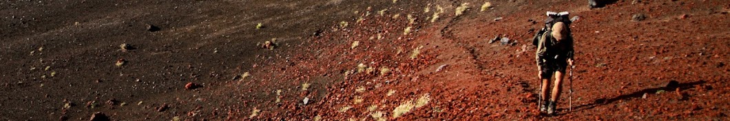
Travesía por los Andes Ocultos | 1.012 Kilómetros Caminando el Greater Patagonian Trail
Hola, mi nombre es Martín Hurtado y el año 2020 caminé por 42 días siguiendo el Greater Patagonian Trail. Una ruta creada por Jan Dudeck y Meylin Ubilla en la zona sur de Chile, que se extiende desde las afueras de Santiago, por la Cordillera de los Andes hasta el Chaltén.
Con la inquietud de conocer los valles cordilleranos ocultos y su gente, de tener una experiencia de inserción prolongada en la naturaleza y de ponerme a prueba física y mentalmente en una caminata de grandes distancias y soledad, es que me dispuse a recorrer esta impresionante ruta. Una instancia única que comprueba aún más los diversos y bellos paisajes de Chile y sus pobladores. Geografía de volcanes, ríos, lagos, lagunas, glaciares, bosques y montañas que cambian valle a valle.
_
Hiking Through the Unseen Andes | 1.012 Kilometers in the Greater Patagonian Trail
Hello, my name is Martin Hurtado and in the begining of 2020 I hiked for 42 days following the Greater Patagonian Trail. An amazing route created by the german Jan Dudeck in southern Chile, extending from the outskirts of Santiago, through the Cordillera de los Andes until el Chaltén.
With the curiosity of deeply knowing the hidden valleys of the Cordillera and its people, of having a prolonged experience of inmersion in nature, and testing myself both physically and mentally in a hike of great distances and solitude, Is that I began this incredible trail. A unique instance which further proves the diverse and beautiful landscapes of Chile and its dwellers. A geography of volcanoes, rivers, lakes, lagoons, glaciers, forests and mountains that change in each valley.
Inspired by @Kraig Adams
_
Greater Patagonian Trail:
www.wikiexplora.com/Greater_Patagonian_Trail
MUSIC:
TH-cam license: copyright holders may monetize the video, otherwise Creative Commons noted below.
Alps - Novo Amor & Ed Tullet
Silvery - Novo Amor & Ed Tullet
Ontario - Novo Amor & Ed Tullet
Terraform - Novo Amor & Ed Tullet
There is a Place by Scott Buckley - www.scottbuckley.com.au
Petrichor by Scott Buckley - www.scottbuckley.com.au
Instagram: @martinhurizq
martinhurizq
มุมมอง: 5 693
How technical and difficult was it through the volcanoes stages? I've been following GPT posts on Facebook but would like your opinion. How were the river crossings?
Ando buscando información de como llegar a laguna Liay y me encuentro con esta joya de video, como la hiciste para llegar allá? hablaste con las personas de trapa trapa?
Una gran motivación audiovisual para que más gente recorra por estos remotas y maravillosas rutas de Chile. Felicitaciones y gracias!
Beautiful movie, incredible performance!
tremendo viaje, gracias por registrarlo. La ruta por pulul fue lo que no pudiste hacer por mal tiempo?
Muy bonitas Tomas! Me gusta tu mirada... Que ganas de estar en Patagonia ya :D
hermosa y harta dificil travesia . te felicito y envidio a la vez por la realizacion .espero q hayas podido hacer las otras secciones y poder ver el material .. gracias y saludos desde Argentina..
Tremenda travesía! Felicitsciones por lograr el objetivo y Gracias por compartir el logro, me encantó! Me gustaría saber que elementos conformaban tus 6,5kg base y si hubieses cambiado algo de lo planificado luego de la experiencia. Abrazos
Thanks for sharing Martin; I am headed there for the end of this month. When did you do your hike? At what time of the year?
You are welcome Damien. Great to hear you are coming to walk the GPT. I started at the begining of January. Great timing for the high passes where there was little snow and also for river crossings. The heat is the major disadvantage.
Muy buen trabajo y felicitaciones por tu logro. Déjame decirte que se nota la calidad en todas las tomas, así que valió la pena haberte tomado el tiempo y la energía de andar con la cámara y saber ubicarla.
Muchas gracias Michael! Primer video pero valió la pena. Es mucho trabajo grabar en el cerro, pero da otra perspectiva de la experiencia en el lugar. Felicitaciones por tus videos igual! A seguir mostrando Chile.
Felicitaciones Martín por semejante actitud de enfrentar semejante desafió !!! Abrazo !!
Muchas gracias Marian! Saludos.
Amazing video man!
Thanks man! My first one. Checked your channel, amazing content! I will try and do the same with videos of Chile.
Stunning views what a great hike, gj!
Thanks Oliver! There is a lot to see in Chile. Great channel and videos by the way.
@@hurtadofcb Thanks! Look forward to more videos from you :D
Absolutamente impresionante. Muy bien hecho. Espero hacer esto. Actualmente estoy leyendo el manual de excursionistas de GPT. ¿Fue sencilla siguiendo el rastro con el GPS? ¿Había generalmente algún tipo de evidencia de un rastro? ¿Cuánto tiempo duró el desvío de reabastecimiento más largo? Como llegaste al comienzo de la seccion 5? Muchas gracias por publicar. Absolutely stunning. Very well done. I hope to do this. Im currently reading the GPT hikers handbook. Was it straight forward following the trail with the GPS? Was there usually some type of evidence of a trail? How long was the longest resupply diversion? How did you get to the beginning of section 5?Thank you so much for posting.
Hello! Thank you! Glad to read you are planning on walking the GPT. Following the gps tracks is not difficult, but good orientation skills are a must. There are cross country sections where you have to judge the best route, or a trail that disappear from one season to the other. There are no official trail blazes or signage. The longest resupply was 8 days I think, but that highly depends on your pace, combining sections or alternative routes you may chose. I havent walked section 5, I started at GPT 06. But 05 is not a good one to start since is the hardest one.
Es impresionante tu recorrido, te felicito, auspicioso futuro a lo Jan Dudeck o Iohan Gueorguiev. Demuestras que existen varias rutas o lugares que pesan tanto como las icónicas Torres del Paine. Felicitaciones y Gracias por compartir.
Gracias Andrés. Exactamente, Chile está lleno de lugares únicos, siendo especialmente atractivos los paisajes volcánicos. El trabajo de años de Jan rescata estos rincones poco visitados. Mucha suerte de la variedad de naturaleza que tenemos.
uno de mis sueños. gracias por filmar esta hermosura
De nada!
I'm seeing youre carrying the lanshan tent. Is it the pro version? And how did it end up working on a long thru hike? I've got it myself but have never seen thru-hike reviews on it, thanks :)
Hello! Yes, it is the Lanshan Pro. I used it for half the thru hike when going solo. It performed really well in some high winds and rain (I seamed sealed it), never collapsed and always dry. No signs of wear and teat anywhere. Always pitched it high to avoid condensation, but I was also really mindful about campsite selection. Inside is quite big, so did not touch the walls. I've read that the built quality is even better than the Lunar Solo. I think it lasts a thru hike with no problem. I only pitched it with all the stakes and guylines in storms, using MSR Groundhogs in the main points. Really simplistic and easy to pitch, single wall, which I loved. I really did not have any issues with this tent. Having said all of this, I still recently purchased a MLD Doumid for southern Patagonia, in which 80 km/h or more winds are common. So for main three season use and a long hike, no problem. But for extreme conditions (which is not designed for) I would not bring it. Feel free to write if you have any questions about the Lanshan.
Increíble! Que hacías para no perder la ruta cuando no había sendero a seguir? tenías experiencias previas en senderos tan largos? Gracias!
Hola Matías! Gracias. Cuando no hay sendero, seguía el track del gps o ciertos waypoints, siempre con algo de instinto para ir eligiendo la mejor ruta. Sólo tenía experiencia en circuitos de hasta 120km, pero al final es similar si uno lo divide todo en secciones, tal cual es el GPT. Lo más difícil es mantener la motivación para caminar casi todos los días por un par de meses. De todas maneras, se necesita harta planificación, entrenamiento y conocimientos de montaña.
Wow dude!
Felicitaciones! Qué gran viaje. Cómo lo hiciste con las provisiones? La ruta contempla puntos para conseguir alimentos? Cuántos kilos de equipo? Saludos!
Hola Ignacio, gracias! La ruta del GPT está dividida en secciones con puntos para comprar provisiones o tomar un bus a un pueblo. Puede revisar en Wikiexplora está todo. Mi peso base fue de 6.5 kilos más comida, dependiendo de los días.
Fabuloso! Gracias por compartir, muy lindas imágenes. Ahora en cuarentena es perfecto para planear y tener una idea de este trail.
¡felicitaciones Martín! ¿Cómo puedo contactarte?
Gracias! Puede ser por mi instagram @martinhurizq
Impresionante! Felicitaciones!
Grande Martin!
Grande Sebastián, gracias.
Impresionante!!!!! Tendrás la ruta para verla en mapa??? Maravilloso viaje
Gracias! En wikiexplora está toda la información. www.wikiexplora.com/Greater_Patagonian_Trail
Felicitaciones!! tremenda experiencia!!!! Respect!
Congratulations, great video!!!!
@Tomás Fernández Comparini jajajajaja
Amazing. I'm planning to start the GPT this year or next, so this it great to see. Thanks!
Thanks David! Good to hear, hopefully this summer.
Que increíble travesía! Bellas imagenes, lo mejor la cordillera chilena!