

- 68
- 315 076
DieFarbe
เข้าร่วมเมื่อ 28 เม.ย. 2014
Hi there! This channel is for civil engineering students. In this channel I'll upload videos related to higher studies abroad in civil engineering. GIS, RStudio and scholarships in different countries for masters and Phd will be focused. Thank you. Stay tuned.
วีดีโอ


Buffer Analysis in ArcGIS Online | ArcGIS Pro
มุมมอง 1.1Kปีที่แล้ว
Buffer analysis is very important for getting the exact scenario and covering the area around a specific location. This video will drive you the easiest way to perform buffer analysis in ArcGIS Online. Buffer Analysis in ArcGIS Online | ArcGIS Pro

Create Shapefiles with Google Earth Pro | ArcGIS Online
มุมมอง 125ปีที่แล้ว
Create shapefiles easily from Google Earth Pro software. It can be done with Google Earth Explorer Web too. Stay tuned.

Create an ArcGIS online, ArcGIS Pro account for free | ArcGIS Pro | ArcGIS Online
มุมมอง 1.5Kปีที่แล้ว
Create an ArcGIS online, ArcGIS Pro account for free | ArcGIS Pro | ArcGIS Online

How to create features, edit features in ArcGIS
มุมมอง 61ปีที่แล้ว
How to create features, edit features in ArcGIS
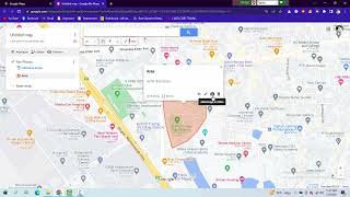
Add Layer, Edit Layers, Draw Lines And Areas In Google Map
มุมมอง 43K2 ปีที่แล้ว
Add Layer, Edit Layers, Draw Lines And Areas In Google Map

Web Editing Avec Using ArcGIS Full Tutorial
มุมมอง 942 ปีที่แล้ว
Web Editing Avec Using ArcGIS Full Tutorial
Cartographic atlas production with ArcGIS
มุมมอง 702 ปีที่แล้ว
Cartographic atlas production with ArcGIS
Georeferencing a Topographic map on ArcMap
มุมมอง 1632 ปีที่แล้ว
Georeferencing a Topographic map on ArcMap
How Drug well looks | ড্রাগ ওয়েল কেমন দেখা যায়
มุมมอง 2002 ปีที่แล้ว
How Drug well looks | ড্রাগ ওয়েল কেমন দেখা যায়
Learn How to Convert Google Earth KMZ file to Esri Shapefile
มุมมอง 1.9K2 ปีที่แล้ว
Learn How to Convert Google Earth KMZ file to Esri Shapefile
Enlisting of maps according to a satellite image in ArcGIS
มุมมอง 492 ปีที่แล้ว
Enlisting of maps according to a satellite image in ArcGIS
How to create a point type shapefile in ArcGIS || DieFarbe
มุมมอง 592 ปีที่แล้ว
How to create a point type shapefile in ArcGIS || DieFarbe
Create a polyline type shapefile and vectorize roads
มุมมอง 442 ปีที่แล้ว
Create a polyline type shapefile and vectorize roads
Labels, Superscript and Subscript in ArcGIS || DieFarbe
มุมมอง 5882 ปีที่แล้ว
Labels, Superscript and Subscript in ArcGIS || DieFarbe
Download Climate Data (Temperature, Precipitation, Humidity and more) for free
มุมมอง 6422 ปีที่แล้ว
Download Climate Data (Temperature, Precipitation, Humidity and more) for free
How to download earth data ASTER GDEM V3 from NASA for free || DieFarbe
มุมมอง 2472 ปีที่แล้ว
How to download earth data ASTER GDEM V3 from NASA for free || DieFarbe
How to buy data from Bangladesh Meteorological Department (BMD)
มุมมอง 1.4K2 ปีที่แล้ว
How to buy data from Bangladesh Meteorological Department (BMD)
How to Download Global Soil Data in ESRI Format | Digital Soil Map | Soil Data | ArcMap | Shapefile
มุมมอง 1.6K3 ปีที่แล้ว
How to Download Global Soil Data in ESRI Format | Digital Soil Map | Soil Data | ArcMap | Shapefile
How to use dissolve command in ArcGIS | What is the function of Dissolved tool | ArcMap | DieFarbe
มุมมอง 2203 ปีที่แล้ว
How to use dissolve command in ArcGIS | What is the function of Dissolved tool | ArcMap | DieFarbe
Kriging Interpolation or Kriging Estimation in ArcGIS | ArcMap | Diefarbe
มุมมอง 1673 ปีที่แล้ว
Kriging Interpolation or Kriging Estimation in ArcGIS | ArcMap | Diefarbe
Changing and editing the zooming area in ArcGIS | Different area with different color | ArcMap
มุมมอง 2013 ปีที่แล้ว
Changing and editing the zooming area in ArcGIS | Different area with different color | ArcMap
IMPORT LATTITUDE AND LONGITUDE IN GOOGLE MAP TO FIND LOCATION
HOW TO ADD EXCEL DATA TO GOOGLE MAP LOCATION
How can I obtain SPI at different scales, such as SPI-6, SPI-9, etc.?
Hi sir How are you? Could you please tell me what's its distribution? It is gamma?
How do u do this on phone
❤
Take care always😊
@@RegalynMasucolDurante thanks
Hi. So there any course structural engineering related in Germany? What subject should I choose if I want to work in construction
Great video, my question is how do you give editing permissions to someone you share the map with? I don't see that setting..Thanks
Can I create with a phone?
Background music er jonno to Kothai buja jay na
@@isratjahan3846 sorry for the inconvenience.
for me nathings works
BANGLADESH CYCLONE (UTCV) rainfall
how to export spei data into excel data
not a good video. the video is all about standardized rainfall anomaly and not about standardized precipitation index
omg so many long drawn out steps..
The same can be done with a screenshot of the area and Microsoft Word or Pages on Mac + others. Less complicated and faster.
excuse me sir, how can i make the anomaly index graph but using Southern Oscillation Index (SOI)? are the steps the same like this video? thank you sir
many research papers use gamma distribtion and also normal distribution , can u mention the source where u got this formula ?article ? etc...?
We change the area but visible????? Or not visible
Aslam alikm...please could you tell me that .. from where you have take the precipitation data
I bought data from meteorological department
@@DieFarbeo in precipitation column did you take the mean of monthly precipitation or sum of monthly precipitation what is its unit??
@@DieFarbeo also plz share the link where i want to download this spi tool....
Thank u sir ,it's very helpful
Welcome 😊
hello Mr. where can i download the SPI data?
You've to collect precipitation data from meteorological department
Hi sir, where can i download the exe file
My laptop is no have local users and group?
Sir can you please tell, how to calculate SPI for one station
thankyou
Welcome 😊
you should have given the spei.exe tool link in the description. Everyone is having problem accessing the tool.
sir, i can't find display XY add by click on sheet . i tried many times ... please figure out
❤❤❤
❤❤❤
❤❤❤
❤❤❤
😍😍😍
❤❤❤
check it
Hello sir can i have the excel?
Where are you from?
hi friend' I found the tutorial is very interesting, So, how can we create legend with arrow in both sides just like cbarn legend in grads
Thanks, I've video about that on my channel. Creating Single legend for multiple maps. Please watch that.
good
Thanks
👏👍👍
👍👍👍
Bhai ya mobile sa ho sakta hai
I think it'll work mobile also. You've to open from any browser but change it to desktop version.
@@DieFarbeowhat app should I do for Mobile Please reply g it's a school project
@@Haalandstayhumbleh google map
Good job 👏❤️❤️❤️
I want to discuss with you where should i connect you?
Can we change the colour the colour of route on map
Yes.
How can I get this data sir
Get of what ?
Simplest way is to buy from the country of your residence. Or can download from NOAA or NASA's website.
I like the way you discuss,,❤️❤️❤️
Good job 👏👍
Thanks for sharing this kind of knowledge
Why you're not try to yourself to study there,it's your chance,,good job
hello sir, why did you change dolar sign for ist value and calculate others according to this ist one. but why ist column of the said value is not changed?